Argyll
| Argyll | |
|---|---|
Historic county | |
 | |
| Country | Scotland |
| County town | Inveraray |
| Area | |
| • Total | 3,110 sq mi (8,055 km2) |
Ranked 2nd of 34 | |
| Chapman code | ARL |
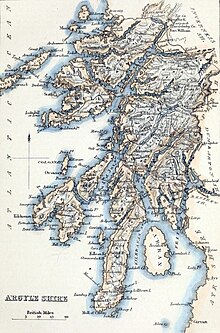
Argyll c. 1854
Argyll (/ɑːrˈɡaɪl/) (archaically Argyle, Earra-Ghàidheal in modern Gaelic pronounced [ˈaːr̴əɣɛː.əɫ̪]), sometimes anglicised as Argyllshire, is a historic county and registration county of western Scotland.
Argyll is of ancient origin, and corresponds to most of the part of the ancient kingdom of Dál Riata on Great Britain. Argyll was also a medieval bishopric with its cathedral at Lismore, as well as an early modern earldom and dukedom, the Dukedom of Argyll.
It borders Inverness-shire to the north, Perthshire and Dunbartonshire to the east, and —separated by the Firth of Clyde— neighbours Renfrewshire and Ayrshire to the south-east, and Buteshire to the south.
Between 1890 and 1975, Argyll was an administrative county with a county council. Its area corresponds with most of the modern council area of Argyll and Bute, excluding the island of Bute and the Helensburgh area, but including the Morvern and Ardnamurchan areas of the Highland council area.
There was an Argyllshire constituency of the Parliament of Great Britain from 1708 until 1983.
Contents
1 Name
1.1 North Argyll
2 Shire, county and district
3 Constituency
4 Civil parishes
5 Residents
5.1 Clans
5.2 Other notable residents
6 In fiction
7 See also
8 Notes
9 References
10 Further reading
11 External links
Name
The name derives from Old Gaelic airer Goídel (border region of the Gaels). The early 13th-century author of De Situ Albanie wrote that "the name Arregathel means margin (i.e., border region) of the Scots or Irish, because all Scots and Irish are generally called Gattheli (i.e. Gaels), from their ancient warleader known as Gaithelglas." The De Situ Albanie is however of dubious authenticity.
However, the word airer naturally carries the meaning of the word 'coast' when applied to maritime regions, so the placename can also be translated as "Coast of [the] Gaels". Woolf has suggested that the name Airer Goídel replaced the name Dál Riata when the 9th-century Norse conquest split Irish Dál Riata and the islands of Alban Dál Riata off from mainland Alban Dál Riata. The mainland area, renamed Airer Goídel, would have contrasted with the offshore islands of Innse Gall, literally "islands of the foreigners." They were referred to this way because during the 9th to 12th centuries, they were ruled by Old Norse-speaking Norse–Gaels.[1]
North Argyll
The term North Argyll historically referred to what is now called Wester Ross. It acquired the name North Argyll as it was settled by missionaries and refugees from Dál Riata, based at the abbey of Applecross. The position of abbot was hereditary, and when Ferchar mac in tSagart, son of the abbot, became the Earl of Ross, the region of North Argyll started to acquire the name Wester Ross. Both names continued in use until the 15th century, when Wester Ross became the exclusive term.
Shire, county and district
Historically, the term shire is somewhat misleading, as it must not be confused with an English county. In medieval Latin, the latter was referred to as a comitatus, which prior to 1889 a Scottish shire had never been. In Scotland, the comitatus was in fact the region controlled as a Lordship (as opposed, for example, to a Lairdship), such as a mormaerdom, or an early Earldom, and typically survived as a regality (though this is a broader term encompassing also more junior authority). Shire instead came into use, in Scotland, to refer to the region in which a particular sheriff operated; in Scottish medieval Latin this was sometimes called the vice-comitatus.
Following the transfer of the Hebrides and adjacent mainland coast from Norway to Scotland, by the 1266 Treaty of Perth, Argyll was served by the sheriff of Perth. However, in 1293, king John Balliol established the post of sheriff of Kintyre. In 1326[2], Dougall Campbell, son of Neil Campbell, was rewarded for Campbell support of Robert the Bruce; Dougall was grandson of the baron of Innis Chonnell, at the centre of the Argyll region, so he was created Sheriff of Argyll. However, the sheriffdom had only been created to oversee the forfeited MacDougall territory of Lorn (including Mull), the southern parts of Argyll remained part of the quasi-independent Lordship of the Isles until the late 15th century.
In 1476, John MacDonald, the Lord of the Isles, quitclaimed Kintyre and Knapdale (including the region between Loch Awe and Loch Fyne) to Scotland, and initially Knapdale was served by the Sheriff of Perth. However, in 1481, it was placed under the control of Tarbertshire - an expanded sheriffdom of Kintyre.
The Scottish Reformation co-incidentally followed the fall of the Lordship of the Isles, but the MacDonalds - former lords - were strong supporters of the former religious regime. The Campbells by contrast were strong supporters of the reforms, so at the start of the 17th century, under instruction from James VI, the Campbells were sent to Islay and Jura - MacDonald territory - to subdue the MacDonalds. The sheriffdom of Argyll was an inherited position, and had remained in the Campbell family, and now it was extended to include Islay and Jura. Campbell pressure at this time also lead to the sheriff court for Tarbertshire being moved to Inverary, where the Campbells held the court for the sheriff of Argyll. Somewhat inevitably, in 1633, Tarbertshire was abolished, in favour of the sheriff of Argyll.
David II had restored MacDougall authority over Lorn in 1357, but John MacDougall (head of the MacDougalls) had already renounced claims to Mull (in 1354) in favour of the MacDonalds, to avoid potential conflict. The MacLeans were an ancient family based in Lorn (including Mull), and following the quitclaim, they no longer had a Laird in Mull, so themselves became Mull's Lairds. Unlike the MacDonalds, they were fervent supporters of the Reformation, even supporting acts of civil disobedience against king Charles II's repudiation of the Solemn League and Covenant. Archibald Campbell (Earl of Argyll) was instructed by the privy council to seize Mull, and suppress the non-conformist behaviour; by 1680 he gained possession of the island, and transferred shrieval authority to the sheriff of Argyll.
| Historical Argyll population | ||
|---|---|---|
| Year | Pop. | ±% |
| 1801 | 81,277 | — |
| 1811 | 86,541 | +6.5% |
| 1821 | 97,316 | +12.5% |
| 1831 | 100,973 | +3.8% |
| 1841 | 97,371 | −3.6% |
| 1851 | 89,298 | −8.3% |
| 1901 | 73,642 | −17.5% |
| 1911 | 70,902 | −3.7% |
| 1921 | 76,862 | +8.4% |
| 1931 | 63,050 | −18.0% |
| 1951 | 63,361 | +0.5% |
| Source: [3] | ||
In 1746, following Jacobite insurrections, the Heritable Jurisdictions Act abolished regality, and forbade the position of sheriff from being inherited. Local governance was brought into line with that of the rest of Great Britain. Boards for health, water, education, the poor law, and so on, were established for each sheriffdom, akin to the way counties were now governed in England. In 1889, counties were at last formally created in Scotland, by a dedicated Local Government Act; they were to use the same boundaries as sheriffdoms.
Argyll thus gained a county council, which lasted until 1975. Argyll's neighbouring counties were Inverness-shire, Perthshire, Dunbartonshire, Renfrewshire, Ayrshire and Bute. Renfrewshire and Ayrshire are on the other side of the Firth of Clyde, while Bute was a county comprising the islands in the firth.
The county town of Argyll was historically Inveraray, which is still the seat of the Duke of Argyll. Lochgilphead later claimed to be the county town, as the seat of local government for the county from the 19th century. Neither town was the largest settlement geographically, nor in terms of population, however. Argyll's largest towns were (and are) Oban, Dunoon and Campbeltown.
The Small Isles of Muck or Muick, Rhum or Rùm, Canna and Sanday were part of the county until they were transferred to Inverness-shire in 1891 by the boundary commission appointed under the Local Government (Scotland) Act 1889. The island of Egg or Eigg was already in Inverness-shire.
The concept of a County of Argyll ceased for local government purposes in 1975, with its area being split between Highland and Strathclyde Regions. A local government district called Argyll and Bute was formed in the Strathclyde region, including most of Argyll and the adjacent Isle of Bute (the former County of Bute was more extensive). The Ardnamurchan, Ardgour, Ballachulish, Duror, Glencoe, Kinlochleven and Morvern areas of Argyll were detached to become parts of Lochaber District, in Highland. They remained in Highland following the 1996 revision.

Oronsay Priory, Oronsay, Inner Hebrides was recently 'improved' in anticipation of Queen Elizabeth's visit.

Coast of Colonsay
In 1996 a new unitary council area of Argyll and Bute was created, with a change in boundaries to include part of the former Strathclyde district of Dumbarton.
Constituency
Starting in 1590, as one of the measures that followed the Scottish reformation, each sheriffdom elected commissioners to the Parliament of Scotland. As well as the commissioner representing Argyll, at least one was sent to represent Tarbertshire, Sir Lachlan Maclean of Morvern[4][5][6]. In the 1630 parliamentary session, Sir Coll Lamont, laird of Lamont, was the commissioner for "Argyll and Tarbert".[7])
There was an Argyllshire constituency of the Parliament of Great Britain from 1708 to 1801, and of the Parliament of the United Kingdom from 1801 to 1983 (renamed Argyll in 1950). The Argyll and Bute constituency was created when the Argyll constituency was abolished.
Civil parishes
Civil parishes are still used for some statistical purposes, and separate census figures are published for them. As their areas have been largely unchanged since the 19th century, this allows for comparison of population figures over an extended period of time.
- Ardchattan and Muckairn
- Ardgour
- Ardrishaig
- Ardnamurchan
- Campbeltown
- Coll
Colonsay and Oronsay- Craignish
Dunoon and Kilmun
Gigha and Cara Island- Glassary
Glen Orchy and Inishail- Inveraray
- Inverchaolain
- Jura
- Kilbrandon and Kilchattan
- Kilcalmonell
- Kilchoman
- Kilchrenan and Dalavich
- Kildalton
- Kilfinan
- Kilfinichen and Kilvickeon
- Killarow and Kilmeny
- Killean and Kilchenzie
Kilmallie (part)- Kilmartin
- Kilmodan
- Kilmore and Kilbride
- Kilninian and Kilmore
- Kilninver and Kilmelford
Lismore and Appin- Lochgilphead
Lochgoilhead and Kilmorich- Morvern
- North Knapdale
- Saddell and Skipness
- South Knapdale
- Southend, Argyll
- Strachur
- Strathlachlan
- Tiree
- Torosay, Mull
Residents
Most common surnames in Argyll at the time of the United Kingdom Census of 1881,[8] by order of incidence:
- Campbell
- McDonald
- Cameron
- McLean
- McMillan
- McIntyre
- McDougall
- McCallum
- McKinnon
- McArthur
Clans
Clan Campbell was the main clan of this region. The Campbell clan hosted the long line of the Dukes of Argyll.
Clan Gregor historically held a great deal of lands in this region prior to the proscription of their name in April 1603, the result of a power struggle with the Campbells.
Clan Lamont historically both allied and feuded with the Campbell clan, culminating in the Dunoon Massacre. In the 19th century, theclan chief sold his lands and relocated to Australia, where the current chief lives.
Clan McCorquodale held lands around Loch Awe from the early medieval period until the early 18th century. Their seat was a castle on Loch Tromlee.
Clan Malcolm Also known as MacCallum. The Malcolm clan seat is Duntrune Castle on the banks of Loch Crinan
Clan MacLean Historically held lands on the Isle of Mull with its seat at Duart Castle
Clan MacLachlan historically feuded with the Campbells, and espoused Jacobitism. Held lands on both sides of Loch Fyne, with its seat in Strathlachlan.
Other notable residents
Patrick MacKellar, (1717–1778), born in Argyll, military engineer, achieved his reputation on projects in the United States of America.[9]
Baron Robertson of Port Ellen KT, GCMG, FRSA, FRSE, PC (born 12 April 1946, George Islay MacNeill Robertson), British Labour politician and tenth Secretary General of the North Atlantic Treaty Organisation
Eric Blair, better known as George Orwell, who resided in the northernmost part of Jura, during the final years of his life (1946-1950). During this period, he wrote Nineteen Eighty-Four.- Frances Ruth Shand Kydd (née Roche; 20 January 1936 – 3 June 2004) was the mother of Diana, Princess of Wales. She was resident at Ardencaple House on the Island of Seil. She was buried in Pennyfuir Cemetery on the outskirts of Oban.
In fiction
Rosemary Sutcliff's novel The Mark of the Horse Lord (1965) is set in Earra Gael, i.e. the Coast of the Gael, wherein the Dal Riada undergo an internal struggle for control of royal succession, and an external conflict to defend their frontiers against the Caledones.- The highlands above the village of Lochgilphead were used for a scene in the 1963 film From Russia with Love, starring Sean Connery as James Bond. He killed two villains in a helicopter by firing gunshots at them.
- The main focus of the song The Queen of Argyll is that of a beautiful woman, from Argyll. The song was sung by the band Silly Wizard.
- The 1985 Scottish movie Restless Natives used Lochgoilhead to film a chase scene, as well as some roads just outside the village.
- The housekeeper Elsie Carson in Julian Fellowes' television drama Downton Abbey is from Argyll.
See also
- List of counties of Scotland 1890–1975
- Medieval Diocese of Argyll
- Argyle pattern
- Duke of Argyll
Notes
^ Woolf, Alex. "The Age of the Sea-Kings: 900–1300," in Omand (2006) pp. 94–95
^ MacNair, Peter (1914). Argyllshire and Buteshire. Cambridge County Geographies. London: Cambridge University Press. pp. 1, 69.
^ Vision of Britain
^ "RPS, 1633/6/14". Retrieved 4 July 2017.
^ "Parliaments of Scotland, 1357–1707" (PDF). Return of the name of every member of the lower house of parliament of England, Scotland, and Ireland, with name of constituency represented, and date of return, from 1213 to 1874; Part II: Great Britain, United Kingdom, Scotland, Ireland (PDF)|format=requires|url=(help). Command papers. C.69-I. HMSO. 11 August 1879. pp. 539–556.
^ Porritt, Edward; Porritt, Annie Gertrude (1903). "Patt V: Scotland; Chapter xxxv: The franchise in the counties". The Unreformed House of Commons. Vol.2: Scotland and Ireland. Cambridge University Press. p. 78.
^ "RPS, A1630/7/1". Retrieved 4 July 2017.
^ Most Common Surnames in Argyll
^ Who Was Who in America, Historical Volume, 1607–1896. Chicago: Marquis Who's Who. 1963.
References
- Omand, Donald (ed.) (2006) The Argyll Book. Edinburgh. Birlinn. ISBN 1-84158-480-0
Further reading
The Imperial gazetteer of Scotland Vol. I. page 78, by Rev. John Marius Wilson.
External links
"Filming locations", From Russia with Love (1963), IMDB- Argyll.org – Argyll Independent Visitor Information
- Argyll and Argyle Visitor Information
- Visitor information for Inveraray, Tarbert, Knapdale, Crinan and Lochgilphead
Coordinates: 56°15′N 5°15′W / 56.250°N 5.250°W / 56.250; -5.250

 Clash Royale CLAN TAG#URR8PPP


