Lamington, Queensland
Lamington, Queensland
Jump to navigation
Jump to search
Lamington Queensland | |||||||||||||||
|---|---|---|---|---|---|---|---|---|---|---|---|---|---|---|---|
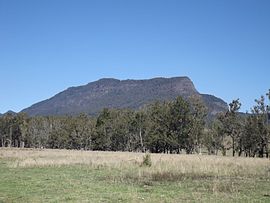 Mount Widgee, 2014 | |||||||||||||||
 Lamington | |||||||||||||||
| Coordinates | 28°15′32″S 153°0′41″E / 28.25889°S 153.01139°E / -28.25889; 153.01139Coordinates: 28°15′32″S 153°0′41″E / 28.25889°S 153.01139°E / -28.25889; 153.01139 | ||||||||||||||
| Population | 463 (2011)[1] | ||||||||||||||
| Established | 1997 | ||||||||||||||
| Postcode(s) | 4211 | ||||||||||||||
| LGA(s) | Scenic Rim Region | ||||||||||||||
| State electorate(s) | Scenic Rim | ||||||||||||||
| Federal Division(s) | Wright | ||||||||||||||
| |||||||||||||||
Lamington is a rural locality in the Scenic Rim Region, Queensland, Australia.[2] In the 2011 census, Lamington and surrounding localities had a population of 463 people.[1]
Contents
1 Geography
2 Railway
3 References
4 External links
Geography[edit]
Christmas Creek is one of a number of tributaries of the Logan River which have headwaters in the McPherson Range along the border. The upper Christmas Creek valley is mountainous. Peaks at Lamington include Little Widgee Mountain, Bujera in the east while across the valley the slopes rise towards Neglected Mountain. The southern boundary follows a section of the western Lamington Plateau and Lamington National Park.
Railway[edit]
Lamington was the terminus for one branch of the Beaudesert Shire Tramway. It operated from 1910 to 1944.[3]
References[edit]
^ ab Australian Bureau of Statistics (31 October 2012). "Innisplain (SSC)". 2011 Census QuickStats. Retrieved 2 April 2016..mw-parser-output cite.citationfont-style:inherit.mw-parser-output qquotes:"""""""'""'".mw-parser-output code.cs1-codecolor:inherit;background:inherit;border:inherit;padding:inherit.mw-parser-output .cs1-lock-free abackground:url("//upload.wikimedia.org/wikipedia/commons/thumb/6/65/Lock-green.svg/9px-Lock-green.svg.png")no-repeat;background-position:right .1em center.mw-parser-output .cs1-lock-limited a,.mw-parser-output .cs1-lock-registration abackground:url("//upload.wikimedia.org/wikipedia/commons/thumb/d/d6/Lock-gray-alt-2.svg/9px-Lock-gray-alt-2.svg.png")no-repeat;background-position:right .1em center.mw-parser-output .cs1-lock-subscription abackground:url("//upload.wikimedia.org/wikipedia/commons/thumb/a/aa/Lock-red-alt-2.svg/9px-Lock-red-alt-2.svg.png")no-repeat;background-position:right .1em center.mw-parser-output .cs1-subscription,.mw-parser-output .cs1-registrationcolor:#555.mw-parser-output .cs1-subscription span,.mw-parser-output .cs1-registration spanborder-bottom:1px dotted;cursor:help.mw-parser-output .cs1-hidden-errordisplay:none;font-size:100%.mw-parser-output .cs1-visible-errorfont-size:100%.mw-parser-output .cs1-subscription,.mw-parser-output .cs1-registration,.mw-parser-output .cs1-formatfont-size:95%.mw-parser-output .cs1-kern-left,.mw-parser-output .cs1-kern-wl-leftpadding-left:0.2em.mw-parser-output .cs1-kern-right,.mw-parser-output .cs1-kern-wl-rightpadding-right:0.2em
^ "Lamington (entry 45158)". Queensland Place Names. Queensland Government. Retrieved 2 April 2016.
^ "Hillview Tramway Station Monument". Monument Australia. Retrieved 30 March 2016.
External links[edit]
![]() Media related to Lamington, Queensland at Wikimedia Commons
Media related to Lamington, Queensland at Wikimedia Commons
This Queensland location article is a stub. You can help Wikipedia by expanding it. |
Categories:
- Scenic Rim Region
- 1997 establishments in Australia
- Populated places established in 1997
- Queensland geography stubs
(window.RLQ=window.RLQ||).push(function()mw.config.set("wgPageParseReport":"limitreport":"cputime":"0.316","walltime":"0.461","ppvisitednodes":"value":1422,"limit":1000000,"ppgeneratednodes":"value":0,"limit":1500000,"postexpandincludesize":"value":56615,"limit":2097152,"templateargumentsize":"value":6440,"limit":2097152,"expansiondepth":"value":13,"limit":40,"expensivefunctioncount":"value":3,"limit":500,"unstrip-depth":"value":1,"limit":20,"unstrip-size":"value":8733,"limit":5000000,"entityaccesscount":"value":1,"limit":400,"timingprofile":["100.00% 392.378 1 -total"," 48.68% 190.994 1 Template:Infobox_Australian_place"," 30.45% 119.493 1 Template:Infobox"," 26.10% 102.419 1 Template:Reflist"," 20.32% 79.712 1 Template:Census_2011_AUS"," 18.51% 72.635 3 Template:Cite_web"," 15.99% 62.729 1 Template:Commons_category-inline"," 13.06% 51.243 1 Template:Coord"," 12.20% 47.879 1 Template:Sister-inline"," 12.00% 47.088 1 Template:Short_description"],"scribunto":"limitreport-timeusage":"value":"0.158","limit":"10.000","limitreport-memusage":"value":5146340,"limit":52428800,"cachereport":"origin":"mw1250","timestamp":"20181213040647","ttl":1900800,"transientcontent":false););"@context":"https://schema.org","@type":"Article","name":"Lamington, Queensland","url":"https://en.wikipedia.org/wiki/Lamington,_Queensland","sameAs":"http://www.wikidata.org/entity/Q24190423","mainEntity":"http://www.wikidata.org/entity/Q24190423","author":"@type":"Organization","name":"Contributors to Wikimedia projects","publisher":"@type":"Organization","name":"Wikimedia Foundation, Inc.","logo":"@type":"ImageObject","url":"https://www.wikimedia.org/static/images/wmf-hor-googpub.png","datePublished":"2016-04-02T02:05:52Z","dateModified":"2017-10-29T09:12:51Z","image":"https://upload.wikimedia.org/wikipedia/commons/a/a9/Mount_Widgee.jpg","headline":"rural locality in Queensland, Australia"(window.RLQ=window.RLQ||).push(function()mw.config.set("wgBackendResponseTime":563,"wgHostname":"mw1250"););


