Mutdapilly, Queensland
Mutdapilly, Queensland
Jump to navigation
Jump to search
Mutdapilly City of Ipswich, Queensland | |||||||||||||||
|---|---|---|---|---|---|---|---|---|---|---|---|---|---|---|---|
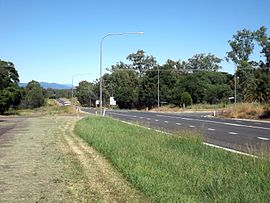 Cunningham Highway, 2015 | |||||||||||||||
 Mutdapilly | |||||||||||||||
| Coordinates | 27°44′32″S 152°39′51″E / 27.74222°S 152.66417°E / -27.74222; 152.66417Coordinates: 27°44′32″S 152°39′51″E / 27.74222°S 152.66417°E / -27.74222; 152.66417 | ||||||||||||||
| Established | 1827 | ||||||||||||||
| Postcode(s) | 4307 | ||||||||||||||
| LGA(s) |
| ||||||||||||||
| State electorate(s) | Scenic Rim | ||||||||||||||
| Federal Division(s) |
| ||||||||||||||
| |||||||||||||||
Mutdapilly is a locality in south-east Queensland, Australia. It is split between the local government areas of City of Ipswich and Scenic Rim Region.[1][2]
Mutdapilly is centrally divided by the north/south running Cunningham Highway. The western boundary follows Warrill Creek. There is one of fifteen air quality monitoring stations in the region located at Mutdapilly.[3] It was established in 1995.
Contents
1 History
2 Heritage listings
3 Notable residents
4 References
5 Further reading
6 External links
History[edit]
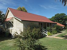
Mutdapilly State School building, 2015
The name Mutdapilly is believed to be a combination word from the Yuggera language (Yugarabul dialect) where mudtherri means sticky or muddy and pilly means gully.[1][2] The name was give by Captain Patrick Logan on 9 June 1827.[4]
Local resident, Mr Denman, donated 2 acres of land for a school. The Normanby State School and teacher's residence was opened on 27 April 1874; the first head teacher was John Stanfell Clowes who served at the school until 31 July 1876. The school was renamed Mutdapilly State School on 1 April 1968.[5][6][7]
St Aidan's Church of England was built in Mutdapilly in 1921, designed by Charles Chauvel (the Australian filmmaker). The church closed in 1974 and the building is now used as a residence.[7][8]
Heritage listings[edit]
Heritage listings for Mutdapilly include:
- 4 Mutdapilly-Churchbank Weir Road: Mutdapilly State School[9]
Notable residents[edit]
Charles Chauvel, early Australian filmmaker
References[edit]
^ ab "Mutdapilly (Ipswich City) (entry 46553)". Queensland Place Names. Queensland Government. Retrieved 27 February 2014..mw-parser-output cite.citationfont-style:inherit.mw-parser-output qquotes:"""""""'""'".mw-parser-output code.cs1-codecolor:inherit;background:inherit;border:inherit;padding:inherit.mw-parser-output .cs1-lock-free abackground:url("//upload.wikimedia.org/wikipedia/commons/thumb/6/65/Lock-green.svg/9px-Lock-green.svg.png")no-repeat;background-position:right .1em center.mw-parser-output .cs1-lock-limited a,.mw-parser-output .cs1-lock-registration abackground:url("//upload.wikimedia.org/wikipedia/commons/thumb/d/d6/Lock-gray-alt-2.svg/9px-Lock-gray-alt-2.svg.png")no-repeat;background-position:right .1em center.mw-parser-output .cs1-lock-subscription abackground:url("//upload.wikimedia.org/wikipedia/commons/thumb/a/aa/Lock-red-alt-2.svg/9px-Lock-red-alt-2.svg.png")no-repeat;background-position:right .1em center.mw-parser-output .cs1-subscription,.mw-parser-output .cs1-registrationcolor:#555.mw-parser-output .cs1-subscription span,.mw-parser-output .cs1-registration spanborder-bottom:1px dotted;cursor:help.mw-parser-output .cs1-hidden-errordisplay:none;font-size:100%.mw-parser-output .cs1-visible-errorfont-size:100%.mw-parser-output .cs1-subscription,.mw-parser-output .cs1-registration,.mw-parser-output .cs1-formatfont-size:95%.mw-parser-output .cs1-kern-left,.mw-parser-output .cs1-kern-wl-leftpadding-left:0.2em.mw-parser-output .cs1-kern-right,.mw-parser-output .cs1-kern-wl-rightpadding-right:0.2em
^ ab "Mutdapilly (Scenic Rim Regional Council) (entry 45212)". Queensland Place Names. Queensland Government. Retrieved 27 February 2014.
^ "South East Queensland". Air monitoring network stations. The State of Queensland. 9 May 2014. Retrieved 16 April 2015.
^ "Indigenous Place Names" (PDF). Ipswich City Council. Retrieved 9 April 2015.
^ "M". Opening and closing dates of Queensland schools. Queensland Government. Retrieved 27 February 2014.
^ "Agency ID152, Mutdapilly State School". Queensland State Archives. Retrieved 27 February 2014.
^ ab "Harrisville & District" (PDF). Ipswich City Council. Archived from the original (PDF) on 6 April 2011. Retrieved 27 February 2014.
^ Starr, Joan (1988), Moreton Shire Queensland : discovery and settlement, Southern Cross PR and Press Services, ISBN 978-0-9588021-0-9
^ "Mutdapilly State School (entry 602840)". Queensland Heritage Register. Queensland Heritage Council. Retrieved 17 December 2017.
Further reading[edit]
Starr, Joan (1988), Moreton Shire Queensland : discovery and settlement, Southern Cross PR and Press Services, ISBN 978-0-9588021-0-9
External links[edit]
![]() Media related to Mutdapilly, Queensland at Wikimedia Commons
Media related to Mutdapilly, Queensland at Wikimedia Commons
- Official website for Mutdapilly State School
Categories:
- Ipswich, Queensland
- Scenic Rim Region
- Populated places established in 1827
- 1827 establishments in Australia
- Mutdapilly, Queensland
(window.RLQ=window.RLQ||).push(function()mw.config.set("wgPageParseReport":"limitreport":"cputime":"0.484","walltime":"0.610","ppvisitednodes":"value":1745,"limit":1000000,"ppgeneratednodes":"value":0,"limit":1500000,"postexpandincludesize":"value":82495,"limit":2097152,"templateargumentsize":"value":7123,"limit":2097152,"expansiondepth":"value":13,"limit":40,"expensivefunctioncount":"value":6,"limit":500,"unstrip-depth":"value":1,"limit":20,"unstrip-size":"value":26048,"limit":5000000,"entityaccesscount":"value":1,"limit":400,"timingprofile":["100.00% 503.970 1 -total"," 39.45% 198.803 1 Template:Infobox_Australian_place"," 34.85% 175.627 1 Template:Reflist"," 23.43% 118.056 7 Template:Cite_web"," 22.13% 111.518 1 Template:Infobox"," 19.52% 98.396 2 Template:Cite_QPN"," 14.00% 70.562 1 Template:Commons_category-inline"," 9.93% 50.060 1 Template:Short_description"," 9.70% 48.890 1 Template:Sister-inline"," 8.77% 44.218 2 Template:If_then_show"],"scribunto":"limitreport-timeusage":"value":"0.231","limit":"10.000","limitreport-memusage":"value":5083681,"limit":52428800,"cachereport":"origin":"mw1266","timestamp":"20181212160716","ttl":1900800,"transientcontent":false););"@context":"https://schema.org","@type":"Article","name":"Mutdapilly, Queensland","url":"https://en.wikipedia.org/wiki/Mutdapilly,_Queensland","sameAs":"http://www.wikidata.org/entity/Q16895621","mainEntity":"http://www.wikidata.org/entity/Q16895621","author":"@type":"Organization","name":"Contributors to Wikimedia projects","publisher":"@type":"Organization","name":"Wikimedia Foundation, Inc.","logo":"@type":"ImageObject","url":"https://www.wikimedia.org/static/images/wmf-hor-googpub.png","datePublished":"2014-02-27T08:33:43Z","dateModified":"2018-02-09T13:35:18Z","image":"https://upload.wikimedia.org/wikipedia/commons/6/62/Cunningham_Highway_at_Mutdapilly.jpg","headline":"locality in Queensland, Australia"(window.RLQ=window.RLQ||).push(function()mw.config.set("wgBackendResponseTime":111,"wgHostname":"mw1322"););


