List of historic properties in Queen Creek, Arizona
List of historic properties in Queen Creek, Arizona
Jump to navigation
Jump to search
List of historic properties in Queen Creek, Arizona | |
|---|---|
City | |
 The Schnepf House | |
 Location in Maricopa County and the state of Arizona |
| Part of a series of the |
| Cities and towns in Arizona with lists and images of historic properties; cemeteries or historic districts |
|---|
Flag of Arizona |
Lists of structures, etc.
|
Lists of cemeteries
|
Historic Districts
|
This is a list, which includes a photographic gallery, of some of the structures of historic significance in Queen Creek, Arizona. When the town was incorporated, it found itself in the unusual situation of part of it located in Maricopa County and the other part in Pina County.
Contents
1 Brief history
2 Properties pictured
3 Historic properties in Queen Creek
4 Further reading
5 See also
6 References
Brief history[edit]

The Desert Wells Stage Stop Marker.

Inside the Schnepf House.
The Valley below the San Tan Mountains had fertile lands. This attracted the Hohokam, a Native American tribe who were the first to establish communities in the area. Then the homesteaders arrived and began to establish farms and ranches along what was called the Queen Creek Wash.[1]
In 1924, Charles Rittenhouse. a land developer, established the Queen Creek Farms Company. The well sin his company pumped 2,150 gallons of water per minute. this helped to make his 1,000 acres of land a very productive one. Soon, a railroad was established in the area and a small grew around the railroad where it could ship the produce and cotton which grew in the farms. The town was called Rittenhouse because the Railroad ran near Rittenhouse and Ellsworth roads. The residents of the area who wanted to travel to Phoenix by train, would often flag the train to get a ride.
In the eastern part of Arizona there is a mountain where the Silver King Mine is located. There is a creek at the base of the mountain which was called Picket Post Creek. Eventually the creeks name was changed to Queen Creek. The creek ran from the mountain and into the area of Rittenhouse.
It wasn't long before the farmers began to rely more on the use of automobiles and trucks then the railroad. The use of the railroad diminished and the people began to call and identify the area as Queen Creek.[2] The town's name officially became known as Queen Creek in 1947, with the establishment of the Queen Creek Post Office. The town, which was incorporated in 1989, has the unique situation of having part of the town located in Maricopa County and the other in Pinal County.[3]
Immigrants from Mexico moved into the area and picked the local cotton crop by hand until the cotton gin came to Queen Creek during the 1920s. In the 1940s the United States set up German P.O.W. camp by Rittenhouse Road. The prisoners, together with immigrants from the Philippine, worked as farm laborers in local fields.[1]
In 1990, members of the community established the San Tan Historical Society. The mission of the society is to preserve the area's heritage. The society collects, preserves, documents, and displays the histories and artifacts of the Chandler Heights, Combs, Higley, and Queen Creek Communities. There are various properties in the town of Queen Creek which are considered historical and have been included either in the National Register of Historic Places or listed as such by the San Tan Historical Society.[4]
Queen Creek however does not have the ability to deny a demolition permit. Therefore, the owner of a property, listed either in the National Register of Historic Places or considered historical by the San Tan Historical Society, may demolish the historical property in question if he or she so desires. An example is the historic Water Tower which was built in 1952 for the Producers Cotton Gin. The water tower was to be demolished, but in 1999, the Schnepf family purchased it and moved it to the grounds of the Schnepf Farms. According to Jim McPherson, Arizona Preservation Foundation Board President:
.mw-parser-output .quoteboxbackground-color:#F9F9F9;border:1px solid #aaa;box-sizing:border-box;padding:10px;font-size:88%.mw-parser-output .quotebox.floatleftmargin:0.5em 1.4em 0.8em 0.mw-parser-output .quotebox.floatrightmargin:0.5em 0 0.8em 1.4em.mw-parser-output .quotebox.centeredmargin:0.5em auto 0.8em auto.mw-parser-output .quotebox.floatleft p,.mw-parser-output .quotebox.floatright pfont-style:inherit.mw-parser-output .quotebox-titlebackground-color:#F9F9F9;text-align:center;font-size:larger;font-weight:bold.mw-parser-output .quotebox-quote.quoted:beforefont-family:"Times New Roman",serif;font-weight:bold;font-size:large;color:gray;content:" “ ";vertical-align:-45%;line-height:0.mw-parser-output .quotebox-quote.quoted:afterfont-family:"Times New Roman",serif;font-weight:bold;font-size:large;color:gray;content:" ” ";line-height:0.mw-parser-output .quotebox .left-alignedtext-align:left.mw-parser-output .quotebox .right-alignedtext-align:right.mw-parser-output .quotebox .center-alignedtext-align:center.mw-parser-output .quotebox citedisplay:block;font-style:normal@media screen and (max-width:360px).mw-parser-output .quoteboxmin-width:100%;margin:0 0 0.8em!important;float:none!important
The historic Schnepf Farms is located five miles southeast of the town. The area was purchased by Jack and Maude Schnepf in 1941. They were among the first settlers to buy a cotton picker, put in cement ditches and dig sumps to catch and recycle wastewater. Jack and Raymond Schnepf invented and manufactured the aluminum irrigation tube. The family purchased various farm buildings from neighboring farms that sold their land to developers adding them to the building structures which were already on their farm. These buildings and structures were moved and rebuilt on their property.[6]
Properties pictured[edit]

Railroad Water Tank.
The following is a brief description of the historic properties that are pictured:
- The Old Rittenhouse Elementary School - located on the S.E. corner of Ellsworth and Queen Creek roads was built in 1925. Used as a school through 1982, this building now houses the San Tan Historical Society. Listed in the National Register of Historic Places in 1998. Reference 98000053
Our Lady of Guadalupe - The first Catholic Church building in Queen Creek is located on the north side of Ocotillo, 3/8 mile west of Ellsworth Road.- The Church of Jesus Christ of Latter-day Saints, now the Queen Creek Town Hall - The building that currently serves as the Town Hall for Queen Creek began as a meetinghouse of the Church of Jesus Christ of Latter-day Saints.
- The Desert Wells Stage Stop Ruins - Located just north of Chandler Heights Road on the east side of Sossaman Road, this site was a small spur stop for the Arizona Stage Company, founded in 1868. The stop provided water, shade, and protection for stages from Florence via Olberg and on to Mesa.
- The Community Church - This was the first church in Rittenhouse. It was a Community Church built in 1921. It stands on the northwest corner of Mandarin Drive and Hunt Highway. Listed as historical by the San Tan Historical Society.
- The Higley General Store - The community of Higley was named after one of its early landowners, Stephen Weaver Higley, born May 3, 1857. The Higley General Store building was built in 1910, The brown structure pictured in the middle is a remodeled version of the original which still stands near the southwest corner of Higley Road and Williams Field Road and now houses various businesses. The first Post Office was in a back corner of the Higley Store. Listed as historical by the San Tan Historical Society.
- The Arizona Boys Ranch - The Arizona Boys Ranch was established in 1951. It is now called Canyon State Academy.
- The Old Post Office Building' - This historic building was built in 1913 and was once the Post Office of Queen Creek. The building is now used for commercial purposes and is located at 22030 S. Rittenhouse Road.
- The Railroad Water Tank - The Railroad Water Tank on Rittenhouse Road was built in the early 1900s.
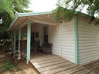
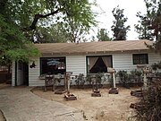
- The Schnepf House - The century old house which once served as the home of Ray and Thora Schnepf. The house is located in the grounds of the Schnepf Farm at 22601 East Cloud Road.
- The Customer Service Farmhouse - A century old house on the grounds of the historic Schnepf Farms.
Water Tower - The historic water tower was built in 1952 for the Producers Cotton Gin. It was moved to the Schnepf Farms in 1999.- The 1912 Parker Carousel - The Schnepf farm is home to the historic 1912 Parker Carousel. The carousel, built by C. W. Parker, has four of the original wooden horses. It was originally purchased from Wally Scott in from Elk River, Minnesota and in 1999 and moved to the Schnepf Farm. It is listed in the national Registry of Historic Carousels.[7]
Hunt Highway - The historic highway, named after George W. P. Hunt the first governor of the "State" of Arizona, was built in 1913. It served travelers from the City of Phoenix to the town of Florence.[8]- The Pyramid House - The house, which represents a pyramid, was built in 1978 and is located at 34317 Goldmine Gulch Trail.
Also pictured is the gravesite of Mansel Carter and Marion E. Kennedy, located in what once was their campsite in Gold Mountain. The area is now within the boundaries of the San Tan Mountain Regional Park.
Historic properties in Queen Creek[edit]
.mw-parser-output .mod-gallerydisplay:table.mw-parser-output .mod-gallery-defaultbackground:transparent;margin-top:0.5em.mw-parser-output .mod-gallery-centermargin-left:auto;margin-right:auto.mw-parser-output .mod-gallery-leftfloat:left.mw-parser-output .mod-gallery-rightfloat:right.mw-parser-output .mod-gallery-nonefloat:none.mw-parser-output .mod-gallery-collapsiblewidth:100%.mw-parser-output .mod-gallery .titledisplay:table-row.mw-parser-output .mod-gallery .title>divdisplay:table-cell;text-align:center;font-weight:bold.mw-parser-output .mod-gallery .maindisplay:table-row.mw-parser-output .mod-gallery .main>divdisplay:table-cell.mw-parser-output .mod-gallery .captiondisplay:table-row;vertical-align:top.mw-parser-output .mod-gallery .caption>divdisplay:table-cell;display:block;font-size:94%;padding:0.mw-parser-output .mod-gallery .footerdisplay:table-row.mw-parser-output .mod-gallery .footer>divdisplay:table-cell;text-align:right;font-size:80%;line-height:1em.mw-parser-output .mod-gallery .gallerybox .thumb imgbackground:none.mw-parser-output .mod-gallery .bordered-images imgborder:solid #eee 1px
(NRHP = National Register of Historic Places)
(STHS = San Tan Historical Society.)
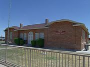
The Old Rittenhouse Elementary School (1925).

Our Lady of Guadalupe (1940's).

The Church of Jesus Christ of Latter-day Saints now the Queen Creek Town Hall (1951).
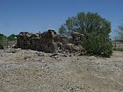
Ruins of the Desert Wells Stage Stop (1868).

Community Church (1921).

Higley General Store (1910).

Arizona Boys Ranch (1951).

Old Post Office Building (1913).

1900's Railroad Water Tank (1900's).

The Schnepf House (1900).
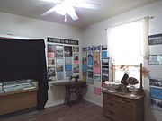
Inside the Schnepf House.
Customer Service Farmhouse (1900).
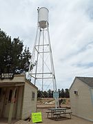
Water Tower (1952)

1912 Parker Carousel.

1912 Parker Carousel original wooden horses.

Historic Hunt Hwy./Wagon Wheel Rd. street sign.

Historic Hunt Highway built in 1913.

Pyramid House built in 1978 and located at 34317 Goldmine Gulch Trail.


Gravesite of Mansel Carter and Marion E. Kennedy.

Gold Mountain.

Goldmine Gulch. The gulch is a narrow and steep-sided ravine marking the course of a fast stream.

Mansel Carter’s gravesite marker in San Tan Mountain Regional Park.

Gravesite of Mansel Carter and Marion E. Kennedy with the Gold Mountain in the background.
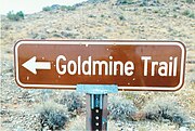
Goldmine Trail sign.

The Goldmine Trail.

Tombstone of Mansel Carter (1902-1987).

Tombstone of Marion E. Kennedy (1874-1960)


Further reading[edit]
- "Queen Creek"; by Sylvia G Acuna; Publisher: Arcadia Publishing Library Editions; .mw-parser-output cite.citationfont-style:inherit.mw-parser-output qquotes:"""""""'""'".mw-parser-output code.cs1-codecolor:inherit;background:inherit;border:inherit;padding:inherit.mw-parser-output .cs1-lock-free abackground:url("//upload.wikimedia.org/wikipedia/commons/thumb/6/65/Lock-green.svg/9px-Lock-green.svg.png")no-repeat;background-position:right .1em center.mw-parser-output .cs1-lock-limited a,.mw-parser-output .cs1-lock-registration abackground:url("//upload.wikimedia.org/wikipedia/commons/thumb/d/d6/Lock-gray-alt-2.svg/9px-Lock-gray-alt-2.svg.png")no-repeat;background-position:right .1em center.mw-parser-output .cs1-lock-subscription abackground:url("//upload.wikimedia.org/wikipedia/commons/thumb/a/aa/Lock-red-alt-2.svg/9px-Lock-red-alt-2.svg.png")no-repeat;background-position:right .1em center.mw-parser-output .cs1-subscription,.mw-parser-output .cs1-registrationcolor:#555.mw-parser-output .cs1-subscription span,.mw-parser-output .cs1-registration spanborder-bottom:1px dotted;cursor:help.mw-parser-output .cs1-hidden-errordisplay:none;font-size:100%.mw-parser-output .cs1-visible-errorfont-size:100%.mw-parser-output .cs1-subscription,.mw-parser-output .cs1-registration,.mw-parser-output .cs1-formatfont-size:95%.mw-parser-output .cs1-kern-left,.mw-parser-output .cs1-kern-wl-leftpadding-left:0.2em.mw-parser-output .cs1-kern-right,.mw-parser-output .cs1-kern-wl-rightpadding-right:0.2em
ISBN 1531675379;
ISBN 978-1531675370 - "Around San Tan Mountain (AZ)"; by David Salge; Publisher: Arcadia Publishing;
ISBN 0738548952;
ISBN 978-0738548951
See also[edit]
| Wikimedia Commons has media related to Buildings in Queen Creek, Arizona. |
- Queen Creek, Arizona
- National Register of Historic Places listings in Arizona
- National Register of Historic Places listings in Maricopa County, Arizona
- National Register of Historic Places listings in Pinal County, Arizona
References[edit]
^ ab HERITAGE REFLECTS TIES TO THE LAND
^ Queen Creek's Name
^ Queen Creek
^ San Tan Historical Society
^ Arizona Preservation Foundation
^ 70 years of Farming and Fun with Schnepf Farms
^ Schnepf Farms Carousel
^ Historic Hunt Highway
Categories:
- Lists of buildings and structures in Arizona
(window.RLQ=window.RLQ||).push(function()mw.config.set("wgPageParseReport":"limitreport":"cputime":"0.456","walltime":"0.631","ppvisitednodes":"value":3415,"limit":1000000,"ppgeneratednodes":"value":0,"limit":1500000,"postexpandincludesize":"value":38224,"limit":2097152,"templateargumentsize":"value":2879,"limit":2097152,"expansiondepth":"value":13,"limit":40,"expensivefunctioncount":"value":0,"limit":500,"unstrip-depth":"value":0,"limit":20,"unstrip-size":"value":38090,"limit":5000000,"entityaccesscount":"value":1,"limit":400,"timingprofile":["100.00% 542.565 1 -total"," 35.44% 192.305 1 Template:Infobox_settlement"," 24.02% 130.301 2 Template:Gallery"," 15.16% 82.251 1 Template:Infobox"," 12.97% 70.357 1 Template:Commons_category"," 12.86% 69.761 4 Template:ISBN"," 8.37% 45.398 1 Template:Short_description"," 7.44% 40.384 4 Template:Catalog_lookup_link"," 5.31% 28.800 1 Template:Quotebox"," 4.84% 26.263 1 Template:Pagetype"],"scribunto":"limitreport-timeusage":"value":"0.170","limit":"10.000","limitreport-memusage":"value":3241617,"limit":52428800,"cachereport":"origin":"mw1319","timestamp":"20181130004526","ttl":1900800,"transientcontent":false););"@context":"https://schema.org","@type":"Article","name":"List of historic properties in Queen Creek, Arizona","url":"https://en.wikipedia.org/wiki/List_of_historic_properties_in_Queen_Creek,_Arizona","sameAs":"http://www.wikidata.org/entity/Q30639903","mainEntity":"http://www.wikidata.org/entity/Q30639903","author":"@type":"Organization","name":"Contributors to Wikimedia projects","publisher":"@type":"Organization","name":"Wikimedia Foundation, Inc.","logo":"@type":"ImageObject","url":"https://www.wikimedia.org/static/images/wmf-hor-googpub.png","datePublished":"2017-05-16T02:57:18Z","dateModified":"2018-11-17T04:05:02Z","image":"https://upload.wikimedia.org/wikipedia/commons/5/52/Queen_Creek-Schnepf_Farms-Schnepf_House-1900-2.jpg"(window.RLQ=window.RLQ||).push(function()mw.config.set("wgBackendResponseTime":756,"wgHostname":"mw1319"););


