Hạ Long Bay
| UNESCO World Heritage site | |
|---|---|
 | |
| Location | Vietnam |
| Criteria | Natural: vii, viii |
| Reference | 672 |
| Inscription | 1994 (18th Session) |
| Extensions | 2000 |
| Coordinates | 20°54′N 107°12′E / 20.9°N 107.2°E / 20.9; 107.2Coordinates: 20°54′N 107°12′E / 20.9°N 107.2°E / 20.9; 107.2 |
 Location of Hạ Long Bay in Vietnam | |
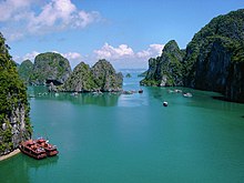
Ha Long Bay (Vietnamese: Vịnh Hạ Long, IPA: [vînˀ hâːˀ lawŋm] (![]() listen)) is a UNESCO World Heritage Site and popular travel destination in Quang Ninh Province, Vietnam. Administratively, the bay belongs to Ha Long City, Cam Pha City, and is a part of Van Don District. The bay features thousands of limestone karsts and isles in various shapes and sizes. Ha Long Bay is a center of a larger zone which includes Bai Tu Long Bay to the northeast, and Cat Ba Island to the southwest. These larger zones share a similar geological, geographical, geomorphological, climate, and cultural characters.
listen)) is a UNESCO World Heritage Site and popular travel destination in Quang Ninh Province, Vietnam. Administratively, the bay belongs to Ha Long City, Cam Pha City, and is a part of Van Don District. The bay features thousands of limestone karsts and isles in various shapes and sizes. Ha Long Bay is a center of a larger zone which includes Bai Tu Long Bay to the northeast, and Cat Ba Island to the southwest. These larger zones share a similar geological, geographical, geomorphological, climate, and cultural characters.
Ha Long Bay has an area of around 1,553 km2, including 1,960–2,000 islets, most of which are limestone. The core of the bay has an area of 334 km2 with a high density of 775 islets.[1] The limestone in this bay has gone through 500 million years of formation in different conditions and environments. The evolution of the karst in this bay has taken 20 million years under the impact of the tropical wet climate.[2] The geo-diversity of the environment in the area has created biodiversity, including a tropical evergreen biosystem, oceanic and sea shore biosystem.[3] Ha Long Bay is home to 14 endemic floral species[4] and 60 endemic faunal species.[5]
Historical research surveys have shown the presence of prehistoric human beings in this area tens of thousands years ago. The successive ancient cultures are the Soi Nhu culture around 18,000–7000 BC, the Cai Beo culture 7000–5000 BC[6] and the Ha Long culture 5,000–3,500 years ago.[7] Ha Long Bay also marked important events in the history of Vietnam with many artifacts found in Bai Tho Mountain, Dau Go Cave, Bai Chay.[7]
500 years ago, Nguyen Trai praised the beauty of Ha Long Bay in his verse Lộ nhập Vân Đồn, in which he called it "rock wonder in the sky".[8] In 1962, the Ministry of Culture, Sports and Tourism of North Vietnam listed Ha Long Bay in the National Relics and Landscapes publication.[9] In 1994, the core zone of Ha Long Bay was listed as a World Heritage Site according to Criterion VII, and listed for a second time according to Criterion VIII.[10]
Contents
1 Etymology
2 Overview
2.1 Location
2.2 Climate
2.3 Population
3 History
3.1 Soi Nhu culture (16,000–5000 BC)
3.2 Cai Beo culture (5000–3000 BC)
3.3 Feudal period
4 Geology and geomorphology
4.1 History of tectonics
4.2 Karst geomorphology value
4.3 Timeline of geologic evolution
5 Ecology
5.1 Environmental damage
6 Awards and designations
7 In literature
7.1 Ancient tales
8 See also
9 References
10 External links
Etymology
The name Ha Long means "descending dragon".
Before 19th century, the name Ha Long Bay had not been recorded in the old books of the country. It has been called An Bang, Luc Thuy, Van Don... In the late 19th century, the name Ha Long Bay appeared on the Maritime Map of France. The French-language Hai Phong News reported "Dragon appears on Ha Long Bay".
According to local legend, when Vietnam had just started to develop into a country, they had to fight against invaders. To assist the Vietnamese in defending their country, the gods sent a family of dragons as protectors. This family of dragons began spitting out jewels and jade. These jewels turned into the islands and islets dotting the bay, linking together to form a great wall against the invaders. Under magics, numerous rock mountains abruptly appeared on the sea, ahead of invaders' ships; the forward ships struck the rocks and each other. After winning the battle, the dragons were interested in peaceful sightseeing of the Earth, and then decided to live in this bay. The place where the mother dragon descended was named Ha Long, the place where the dragon's children attended upon their mother was called Bai Tu Long island (Bai: attend upon, Tu: children, Long: dragon), and the place where the dragon's children wriggled their tails violently was called Bach Long Vy island (Bach: white-color of the foam made when Dragon's children wriggled, Long: dragon, Vy: tail), present day Tra Co peninsula, Mong Cai.[11]
Overview

Thien Cung grotto
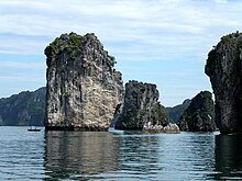
The bay consists of a dense cluster of some 1,600[12]limestone monolithic islands each topped with thick jungle vegetation, rising spectacularly from the ocean. Several of the islands are hollow, with enormous caves. Hang Dau Go (Wooden stakes cave) is the largest grotto in the Ha Long area. French tourists visited in the late 19th century, and named the cave Grotte des Merveilles. Its three large chambers contain large numerous stalactites and stalagmites (as well as 19th-century French graffiti). There are two bigger islands, Tuan Chau and Cat Ba, that have permanent inhabitants, as well as tourist facilities including hotels and beaches. There are a number of beautiful beaches on the smaller islands.

Fisherman's house, Ha Long Bay, Vietnam
A community of around 1,600 people live on Ha Long Bay in four fishing villages: Cua Van, Ba Hang, Cong Tau and Vong Vieng in Hung Thang commune, Ha Long city. They live on floating houses and are sustained through fishing and marine aquaculture (cultivating marine biota), plying the shallow waters for 200 species of fish and 450 different kinds of mollusks. Many of the islands have acquired their names as a result of interpretation of their unusual shapes. Such names include Voi Islet (elephant), Ga Choi Islet (fighting cock), Khi Islet (monkey), and Mai Nha Islet (roof). 989 of the islands have been given names. Birds and animals including bantams, antelopes, monkeys, and lizard also live on some of the islands.

Floating fishing village
Almost all these islands are as individual towers in a classic fenglin landscape with heights from 50m to 100m, and height/width ratios of up to about six.
Another specific feature of Ha Long Bay is the abundance of lakes inside the limestone islands. For example, Dau Be island has six enclosed lakes. All these island lakes occupy drowned dolines within fengcong karst.
Location
Ha Long Bay is located in northeastern Vietnam, from E106°55' to E107°37' and from N20°43' to N21°09'. The bay stretches from Yen Hung district, past Ha Long city, Cam Pha town to Van Don District, bordered on the south and southeast by Lan Ha Bay, on the north by Ha Long city, and on the west by Bai Tu Long Bay. The bay has a 120 km long coastline and is approximately 1,553 km² in size with about 2,000 islets. The area designated by UNESCO as the World Natural Heritage Site incorporates 434 km² with 775 islets, of which the core zone is delimited by 69 points: Dau Go island on the west, Ba Ham lake on the south and Cong Tay island on the east. The protected area is from the Cái Dăm petrol store to Quang Hanh commune, Cam Pha town and the surrounding zone.
Climate
The climate of the bay is tropical, wet, sea islands, with two seasons: hot and moist summer, and dry and cold winter. The average temperature is from 15 °C- 25 °C, and annual rainfall is between 2 meters and 2.2 meters. Ha Long Bay has the typical diurnal tide system (tide amplitude ranges from 3.5-4m). The salinity is from 31 to 34.5MT in the dry season and lower in the rainy season.
Population
Of the 1,969 islands in Ha Long, only approximately 40 are inhabited. These islands range from tens to thousands of hectares in size, mainly in the East and Southeast of Ha Long Bay. In recent decades, thousands of villagers have been starting to settle down on the pristine islands and build new communities such as Sa Tô Island (Hạ Long City), Thắng Lợi Island (Vân Đồn district).
The population of Ha Long Bay is about 1,540, mainly in Cửa Vạn, Ba Hang and Cặp Dè fishing villages (Hùng Thắng Ward, Hạ Long City). Residents of the bay mostly live on boats and rafts to facilitate the fishing, cultivating and breeding of aquatic and marine species. Today the life of Ha Long Bay inhabitants has much improved due to new travel businesses.
At present, the Quảng Ninh provincial government has a policy to relocate the households living in the bay to resettle, in order to stabilize their life and to protect the landscape of the heritage zone. More than 300 households living in fishing villages in Ha Long Bay have been relocated ashore in Khe Cá Resettlement Area, now known as Zone 8 (Hà Phong Ward, Hạ Long City) since May 2014. This project will continue to be implemented. The province will only retain a number of fishing villages for sightseeing tours.
History
Soi Nhu culture (16,000–5000 BC)
Located in Ha Long and Bai Tu Long are archaeological sites such as Me Cung and Thien Long. There are remains from mounds of mountain shellfish (Cyclophorus), spring shellfish (Melania, also called Thiana), some fresh water mollusc and some rudimentary labour tools. The main way of life of Soi Nhu's inhabitants included catching fish and shellfish, collecting fruits and digging for bulbs and roots. Their living environment was a coastal area unlike other Vietnamese cultures, for example, like those found in Hoa Binh and Bac Son.
Cai Beo culture (5000–3000 BC)
Located in Ha Long and Cat Ba island, its inhabitants developed to the level of sea exploitation. Cai Beo culture is a link between Soi Nhu culture and Ha Long culture.[13]
Feudal period
History shows that Ha Long Bay was the setting for local naval battles against Vietnam's coastal neighbors. On three occasions, in the labyrinth of channels in Bach Dang River near the islands, the Vietnamese army stopped the Chinese from landing. In 1288, General Tran Hung Dao stopped Mongol ships from sailing up the nearby Bach Dang River by placing steel-tipped wooden stakes at high tide, sinking the Mongol Kublai Khan's fleet.
During the Vietnam War, many of the channels between the islands were heavily mined by the United States Navy, some of which pose a threat to shipping to this day.
Geology and geomorphology
In 2000, the UNESCO’s World Heritage Committee has inscribed the Ha Long Bay in the World Heritage List according to its outstanding examples representing major stages of the Earth’s history and its original limestone karstic geomorphologic features. The Ha Long Bay and its adjacent areas consist of a part of the Sino-Vietnamese composite terrane having its development history from pre-Cambrian up to present day. During Phanerozoic, terrigenous, volcanogenic and cherty-carbonate sediments containing in abundance graptolites, brachiopods, fishes, corals, foraminiferas, radiolarias, bivalves and flora, separated one from another by 10 stratigraphic gaps, but the boundary between Devonian and Carboniferous has been considered as continuous. The limestone karstic geomorphology of the bay was developed since Miocene, especially the cone-shaped hills (fengcong), or isolated high limestone karst towers (fenglin) with many remnants of old phreatic caves, old karstic foot caves, marine notch caves form magnificent limestone karst landforms as unique on the world. The Quaternary geology was developed through 5 cycles with the intercalation of marine and continental environments. The present Ha Long Bay, in fact, appeared after the Middle Holocene maximum transgression, leaving ultimate zone of lateral undercutting in the limestone cliffs bearing many shells of oysters, having the 14C age as 2280 to >40,000 y. BP. Geological resources are abundant: anthracite, lignite, oil shale, petroleum, phosphate, limestone and cement additives, kaolin, silica sand, dolomite, quartzite of exogenous origin, and antimony, mercury of hydrothermal origin. Besides, there still are surface water, groundwater and thermal mineral water on the shore of the Ha Long - Bái Tử Long Bays and other environmental resources.[14][15]
In terms of marine geology, this area is recorded as an especially coastal sedimentary environment. In the alkaline seawater environment, the chemical denudation process of calcium carbonate proceeds rapidly, creating wide, strangely shaped marine notches.
The bottom surface sediments are various from clay mud to sand, however, silty mud and clay mud are dominated in distribution. Especially, the carbonate materials originated from organisms make up from 60-65% sedimentary content. The surface sediments of coral reefs are mainly sand and pebbles of which the carbonate materials occupy for more than 90%. The intertidal zone sediments are various from clay mud to sand and gravel depending to distinguished sedimentary environments such as mangrove marshes, tidal flats, beaches etc. At the small, but wonderfully beautiful beaches, the sand sediments may be dominated quartz or carbonate materials.
The sediment layers of intertidal zone, the upper sea bed with a plain surface conserving ancient rivers, systems of caves and it's sediments, traces of ancient marine action forming distinctive notches, beaches and marine terraces, mangrove swamps are important evidence of geological events and processes taking place during Quaternary.[16]
History of tectonics
Ha Long Bay has experienced at least 500 million years in various geological states of orogeny, marine transgression and marine regression. During the Ordovician and Silurian periods (500-410 million years ago), Ha Long Bay was deep sea. During the Carboniferous and Permian periods (340-250 million years ago), Ha Long Bay was at shallow sea level.
The dominated uplift movement of neotectonic and recent tectonic influenced deeply on topography of this area, and the present landscape of sea-islands was formed around 7 or 8 thousand years ago by the sea invasion during Holocene transgression begun at about 17-18 thousand years ago. Particularly from the Holocene time, from about 11,000 years ago Cat Ba - Ha Long area has much archaeological evidence connecting variations in sea levels with the development of ancient cultures such as the Soi Nhu and Ha Long cultures.
Karst geomorphology value
Hạ Long Bay
Due to a simultaneous combination of ideal factors such as thick, pale, grey, and strong limestone layers, which are formed by fine-grained materials; hot and moist climate and slow tectonic process as a whole; Ha Long Bay has had a complete karst evolution for 20 million years. There are many types of karst topography in the bay, such as karst field.
Ha Long Bay is a mature karst landscape developed during a warm, wet, tropical climate. The sequence of stages in the evolution of a karst landscape over a period of 20 million years requires a combination of several distinct elements including a massive thickness of limestone, a hot wet climate and slow overall tectonic up lift. The process of karst formation is divided into five stages, the second of which is the formation of the distinctive do line karst. This is followed by the development of fengcong karst, which can be seen in the groups of hills on Bo Hon and Dau Be Inland. These cones with sloping sides average 100m in height with the tallest exceeding 200m. Fenglin karst is characterised by steep separate towers. The hundreds of rocky islands with form the beautiful and famous landscape of the Bay are the individual towers of a classic Fenglin landscape where the intervening plains have been submerged by the sea. Most towers reach a height of between 50 and 100m with a height to width ratio of about 6. The karst dolines were flooded by the sea, becoming the abundance of lakes that lie within the limestone islands. For example, Dau Be island at the mouth of the Bay has six enclosed lakes including those of the Ba Ham lakes lying within its fencong karst. The Bay contains examples of the landscape elements of fengcong, fenglin and karst plain. These are not separate evolutionary stages but the result of natural non – uniform processes in the denudation of a large mass of limestone. Marine erosion created the notches which in some places have been enlarged into caves. The marine notch is a feature of limestone coastline but, in Ha Long Bay, it has created the mature landscape.
Within Ha Long Bay, the main accessible caves are the older passages that survive from the time when the karst was evolving though its various stages of fengcong and fenglin. Three main types of caves can be recognized in the limestone islands (Waltham, T. 1998):
- Remnants of old phreatic caves
- Old karstic foot caves
- Marine notch caves

Sung Sot caves
The first group of caves is old phreatic caves which include Sung Sot, Tam Cung, Lau Dai, Thien Cung, Dau Go, Hoang Long, Thien Long. Nowadays, these caves lie at various high levels. Sung Sot cave is on Bo Hon island. From its truncated entrance chambers on a ledge high on the cliff, a passage of more that 10m high and wide descends to the south. Tam Cung is a large phreatic fissure cave that developed in the bedding planes of the limestone dividing the fissure cave into three chambers. Lau Dai is a cave with a complex of passages extending over 300m opening on the south side of Con Ngua island. Thien Cung and Dau Go are remnants of the same old cave system. They both survive in the northern part of Dau Go island at between 20 and 50m above sea level. Thien Cung has one large chamber more that 100m long, blocked at its ends and almost subdivided into smaller chambers by massive wall of stalactites and stalagmites. Dau Go is a single large tunnel descending along a major set of fractures to a massive choke.
The second group of caves is the old karstic foot caves which include Trinh Lu, Bo Nau, Tien Ong and Trong caves. Foot caves are a ubiquitous feature of karst landscapes which have reached a stage of widespread lateral undercutting at base level. They may extend back into maze caves of stream caves draining from larger cave systems within the limestone. They are distinguished by the main elements of their passages being close to the horizontal and are commonly related to denuded or accumulated terraces at the old base levels. Trinh Nu, which is one of the larger foot caves in Ha Long Bay with its ceiling at about 12m above sea level and about 80m in length, was developed in multiple stages. Bo Nau, a horizontal cave containing old stalactite deposits, cuts across the 25o dip of the bedding plane.
The third group is the marine notch caves that are a special feature of the karst of Ha Long Bay. The dissolution process of sea water acting on the limestone and erosion by wave action crates notches at the base of the cliffs. In advantageous conditions, dissolution of the limestone allows the cliff notches to be steadily deepened and extended into caves. Many of these at sea level extend right though the limestone hills into drowned dolines which are now tidal lakes.
A distinguishing feature of marine notch caves is an absolutely smooth and horizontal ceiling cut through the limestone. Some marine notch caves had been not formed at present sea level, but old sea levels related to sea level changes in Holocene transgression, event to Pleistocene sea levels. Some of them passed preserved the development of old karstic foot cave in mainland environment or preserved the remnants of older phreatic caves. One of the most unusual features of Ha Long Bay is the Bo Ham lake group of hidden lakes and their connecting tunnel – notch caves in Dau Be island. From the island’s perimeter cliff a cave, 10m wide at water level and curving so that it is almost completely dark, extends about 150m to Lake 1. Luon cave is on Bo Hon island and extends 50m though to an enclosed tidal lake. It has a massive stalactite hanging 2m down and truncated at the modern tidal level. It has passed through many stages in its formation.
The karst landscape of Ha Long Bay is of international significance and of fundamental importance to the science of geomorphology. The fenglin tower karst, which is the type present in much of Ha Long Bay, is the most extreme form of limestone landscape development. If these karst landscapes are broadly compared in terms of their height, steepness and number of their limestone towers, Ha Long Bay is probably second in the entire world only to Yangshou, in China. However, Ha Long Bay has also been invaded by the sea so that the geomorphology of its limestone is lands are, at least in part, the consequence of marine erosion. The marine invasion distinguishes Ha Long Bay and makes it unique in the world. There are other areas of submerged karst towers which were invaded by the sea, but none is as extensive as Ha Long Bay.
[15][17]
Timeline of geologic evolution
Some of the most remarkable geological events in Ha Long Bay's history have occurred in the last 1,000 years, include the advance of the sea, the raising of the bay area, strong erosion that has formed coral, and, pure blue and heavily salted water. This process of erosion by seawater has deeply engraved the stone, contributing to its fantastic beauty. Present-day Ha Long Bay is the result of this long process of geological evolution that has been influenced by so many factors.
Due to all these factors, tourists visiting Ha Long Bay are not only treated to one of the natural wonders of the world, but also to a precious geological museum that has been naturally preserved in the open air for the last 300 million years.
| Date | Geologic period | Events |
|---|---|---|
| 570,000,000-500,000,000 BC | beginning of the Cambrian Period | The area, which now forms Ha Long Bay, was basically mainland, subject to a process of rain erosion. |
| end of the Cambrian Period | The area was flooded, commencing the existence of Ha Long Bay. | |
| 500,000,000-400,000,000 BC | Ordovician and Silurian periods | The area of north-east Vietnam was almost like a deep sea, submitted to the constant activity of tectonic plates. |
| end of the Silurian Period | It underwent a phase of inverse-motion that created mountains deep under the water. | |
| 420,000,000-340,000,000 BC | end of the Silurian Period and throughout the whole Devonian Period | The area was subjected to powerful forces of erosion from the hot and dry climate. At this point, Ha Long was part of a wide mainland that comprised most of today's South China Sea and Chinese continental shelf. |
| end of the Devonian Period | Due to tectonic activity, the Ha Long area and the entire north-east region were raised from the depths | |
| 340,000,000-240,000,000 BC | later Carboniferous and Permian periods | The formation of the limestone layer more than 1,000 m thick. A shallow and warm sea reformed, which existed for approximately 100 million years. It created two kinds of limestone: the Cát Bà layer of the early Carboniferous period (450 m thick); and the Quang Hanh layer of the middle Carboniferous and the early Permian period (750 m thick). These two layers constitute the majority of the islands of the Bay. |
| 67,000,000 BC | end of the Cretaceous Period | Ha Long Bay existed in the environment of a high mountainous mainland due to the influence of strong mountain-forming phases. |
| middle of the Paleogene Period | These motions remain continuous and stable, while strong processes of erosion began, and after millions of years, a form of semi-highland topography took shape. The continuation of this erosion has progressively cut the highlands into blocks with altitudes similar to today's mountains | |
| 26,000,000-10,000,000 BC | Neogene Period | The development of the Ha Long depression |
| 2,000,000-9000 BC | Pleistocene epoch of the Quaternary period | The process of erosion began dissolving the limestone-rich region of Ha Long, after that, forming the limestone plain was most active |
| 68,000-9000 BC | middle and late Pleistocene Epoch | Period when the caves and grottoes of the area formed. |
| early Holocene Epoch | The islands of today's Ha Long Bay are basically remnants of these mountains, flooded. Rainwater flowed into crevices in the limestone that had formed from tectonic activity. This steady erosion constantly widened the cracks, eventually creating today's formations. | |
| 9000-5000 BC | Holocene Epoch | This period is notable for the advance of the sea. |
| 5000-2000 BC | The movement of the sea reached its peak and forming today's Ha Long Bay. | |
| 2000–1000 BC | With the sea in a steady process of recession, Ha Long culture began to develop. | |
| beginning of the late Holocene Epoch | The level of the water once again increased, forming a marshy floor of canals and streams, and creating the water marks that can be seen on the stone cliffs of today. |
Ecology
Ha Long Bay is host to two ecosystems: a tropical, moist, evergreen rainforest ecosystem; and a marine and coastal ecosystem. The bay is home to seven endemic species: Livistona Ha Longensis, Impatiens Ha Longensis, Chirita Ha Longensis, Chirita hiepii, Chirita modesta, Paraboea Ha Longensis and Alpinia calcicola.
The many islands that dot the bay are home to a great many other species, including (but likely not limited to): 477 magnoliales, 12 pteris, 20 salt marsh flora; and 4 amphibia, 10 reptilia, 40 aves, and 4 mammalia.
Common aquatic species found in the bay include: cuttlefish (mực); oyster (hào); cyclinae (ngán); prawns (penaeidea (tôm he), panulirus (tôm hùm), parapenaeopsis (tôm sắt), etc.); sipunculoideas (sá sùng); nerita (ốc đĩa); charonia tritonis (ốc tù và); and cà sáy.
Environmental damage
With an increasing tourist trade, mangroves and seagrass beds have been cleared and jetties and wharves have been built for tourist boats.
Game fishing, often near coral reefs, is threatening many endangered species of fish.
Local government and businesses are aware of problems and many measures have been taken to minimize tourism affect to the bay environment for sustainable economic growth like introducing eco friendly tours and introducing tight waste control on resorts.[18]
Awards and designations
In 1962, the Vietnam Ministry of Culture, Sport and Tourism designated Ha Long Bay a 'Renowned National Landscape Monument'.
Ha Long Bay was first listed as a UNESCO World Heritage Site in 1994,[19] in recognition of its outstanding, universal aesthetic value. In 2000 the World Heritage Committee additionally recognised Ha Long Bay for its outstanding geological and geomorphological value,[12] and its World Heritage Listing was updated.[20]
In October 2011, World Monuments Fund included the bay on the 2012 World Monuments Watch, citing tourism pressures and associated development as threats to the site that must be addressed. The goal of Watch-listing is to promote strategies of responsible heritage-driven development for a sustainable future.
In 2012, New 7 Wonders Foundation officially named Ha Long Bay as one of New Seven Natural Wonders of the world.
Ha Long Bay is also a member of the Club of the Most Beautiful Bays of the World.[21]
In literature
In writings about Ha Long Bay, the following Vietnamese writers said:
Nguyễn Trãi: "This wonder is ground raising up into the middle of the high sky".
Xuân Diệu: "Here is the unfinished works of the Beings...Here is the stones which the Giant played and threw away".
Nguyên Ngọc: "...to form this first- rate wonder, nature only uses: Stone and Water...There are just only two materials themselves chosen from as much as materials, in order to write, to draw, to sculpture, to create everything...It is quite possible that here is the image of the future world".
View of Halong Bay
Ho Chi Minh: "It is the wonder that one cannot impart to others".
Phạm Văn Đồng: "Is it one scenery or many sceneries? Is it the scenery in the world or somewhere?".
Nguyễn Tuân: "Only mountains accept to be old, but Ha Long sea and wave are young forever".
Huy Cận: "Night breathes, stars wave Ha Long's water".
Chế Lan Viên:

"Ha Long, Bái Tử Long- Dragons were hidden, only stones still remain
On the moonlight nights, stones meditate as men do..."
Lord Trịnh Cương overflowed with emotion: "Mountains are glistened by water shadow, water spills all over the sky".
Ancient tales
Ha Long bay's inhabitants have developed numerous tales explaining names given to various isles and caves in the bay.[22]
- Dau Go cave (literally: "the end of wooden bars" cave): these wooden bars in this cave are the remnants of sharped wooden columns built under the water level by the order of Trần Hưng Đạo commander in order to sink Mongolian invaders' ships in the 13th century.
- Kim Quy cave (literally: "Golden Turtle" cave): it is told that the Golden Turtle swam toward the Eastern Sea (international name: South China Sea) after returning the holy sword which had assisted King Lê Thái Tổ in the combat against Ming invaders from China. Next, with the approval of the Sea King, Golden Turtle continued to fight against monsters in this marine area. The turtle became exhausted and died in a cave. Consequently, the cave was named after the Golden Turtle.
- Con Coc islet (literally: Frog islet): is a frog- like isle. According to ancient tales, in a year of severe drought, a frog directed all animals to the Heaven and protested against the God. They demonstrated in favour of making rain. As a result, the God must accept the frog as his uncle. Since then, whenever frogs grind their teeth, the God has to pour water down the ground.
- Hang Trong and Hang Trinh Nu (literally: Male cave and Virgin cave): the tale's about a beautiful woman had fallen in love with a fisherman whom must sail to the sea not so long after their engagement, the landlord saw this beautiful girl and captured her, but with her resistance, the landlord exiled the girl to remote island. After being left to starve, the girl was death and turned into a statue in which people called as Hang Trinh Nu (Virgin Cave). Her betrothed ran to the girl's place and found out what had happened, he turned into an islet which situated nearby and called as Hang Trong (Male Cave)[23]

Panorama of Hạ Long Bay, taken on Monkey Island, 2013
See also
- Ha Long
- Việt Nam
- Guilin
- Krabi
References
^ Vịnh Hạ Long. Website chính thức của Ủy ban tổ chức Đại lễ Phật đản Liên Hiệp Quốc 2008 (in Vietnamese)
^ Giá trị địa chất – địa mạo của vịnh Hạ Long. Archived 2009-01-15 at the Wayback Machine. - Trang web chính thức của vịnh Hạ Long (in Vietnamese)
^ Giá trị đa dạng sinh học của vịnh Hạ Long. Archived 2009-01-15 at the Wayback Machine. - Trang web chính thức của vịnh Hạ Long (in Vietnamese)
^ Bảo tồn đa dạng sinh học vịnh Hạ Long" Archived 2009-02-20 at the Wayback Machine. - Tuổi Trẻ Online. Truy cập ngày 29 tháng 10 năm 2007, 17:26GMT (in Vietnamese)
^ Khu văn hóa và lịch sử các đảo vịnh Hạ Long.[permanent dead link] - Website Trường Đại học Khoa học Tự Nhiên Thành phố Hồ Chí Minh (in Vietnamese)
^ Giá trị lịch sử - văn hóa của vịnh Hạ Long. Archived 2009-02-20 at the Wayback Machine. - Trang web chính thức của vịnh Hạ Long (in Vietnamese)
^ ab "Có một nền văn hóa Hạ Long" Archived 2009-02-20 at the Wayback Machine. - Tuổi Trẻ Online (in Vietnamese)
^ "Từ hơn 500 năm trước, vịnh Hạ Long đã được tôn vinh là kỳ quan" - Tuổi Trẻ Online (in Vietnamese)
^ Vị trí địa lý, khí hậu của vịnh Hạ Long. Archived 2009-02-16 at the Wayback Machine. - Trang web chính thức của vịnh Hạ Long (in Vietnamese)
^ "Hạ Long Bay". Retrieved 24 April 2015.
^ Official website of Communist Party of Vietnam - Introduction of Ha Long City Archived 2013-11-01 at the Wayback Machine.
^ ab "Report of Twenty-fourth session of the World Heritage Committee, Cairns, Australia". UNESCO World Heritage Committee. 27 November 2000.
^ "Archived copy". Archived from the original on 2012-02-02. Retrieved 2015-06-07.
^ http://www.idm.gov.vn/nguon_luc/Xuat_ban/2003/22/t1.htm
^ ab Tran Duc Thanh; Waltham Tony (1 September 2001). "The outstanding value of the geology of Ha Long Bay". Advances in Natural Sciences. ResearchGate. 2 (3). ISSN 0866-708X.
^ Tran Duc Thanh, 1998. Geological History of Ha Long Bay
^ Trần Văn Trị, Trần Đức Thạnh, Tony Waltham, Lê Đức An, Lại Huy Anh, 2003. The Ha Long Bay World Heritage: Outstanding geological values. Journal of Geology, Series B. No. 22/2003. p.1-18
^ Charles Sturt University. "HSC Online - Ha Long Bay, Vietnam - a coastal ecosystem in Vietnam". csu.edu.au. Archived from the original on 2008-07-31.
^ "Report of the 18th Session of the World Heritage Committee, Phuket, Thailand, 12–17 December 1994". UNSECO World Heritage Committee. Retrieved 2009-01-18.
^ "Hạ Long Bay - UNESCO World Heritage Site". UNESCO World Heritage Centre. Retrieved 2009-01-18.
^ "The Most Beautiful Bays in the World". Club of the Most Beautiful Bays of the World. Archived from the original on 2013-04-30. Retrieved 2013-05-15.
^ "Ha Long bay- the beauty from tales and history". www.daidoanket.vn. Retrieved 2011-11-12.
^ https://www.halong-bay-cruise.com
External links
| Wikimedia Commons has media related to Vịnh Hạ Long. |
| Wikivoyage has a travel guide for Ha Long Bay. |
UNESCO's World Heritage Convention: Ha Long Bay*
Environmental capacity Ha Long Bay - Bai Tu Long. Publisher: Natural Science and Technology. Hanoi. Editor: Nguyen Khoa Son, ISBN 978-604-913-063-2 – In Vietnamese
Vietnamese Sea and Islands – position Resources, and typical geological and ecological wonders. Publisher Science and Technology. Ha Noi, Editor: Nguyen Khoa Son, ISBN 978-604-913-063-2. In Vietnamese
World Heritage Sites in Vietnam | ||
|---|---|---|
| Cultural heritage |
| |
| Natural heritage |
| |
| Mixed |
| |
| |||||||||||||
| |||||||||||||


Authority control |
|
|---|

 Clash Royale CLAN TAG#URR8PPP


