National Register of Historic Places listings in Armstrong County, Pennsylvania
National Register of Historic Places listings in Armstrong County, Pennsylvania
Jump to navigation
Jump to search
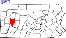
Location of Armstrong County in Pennsylvania
This is a list of the National Register of Historic Places listings in Armstrong County, Pennsylvania.
This is intended to be a complete list of the properties and districts on the National Register of Historic Places in Armstrong County, Pennsylvania, United States. The locations of National Register properties and districts for which the latitude and longitude coordinates are included below, may be seen in a map.[1]
There are 14 properties and districts listed on the National Register in the county.
This National Park Service list is complete through NPS recent listings posted March 22, 2019.[2]
Current listings[edit]
| [3] | Name on the Register | Image | Date listed[4] | Location | City or town | Description |
|---|---|---|---|---|---|---|
1 | Allegheny River Lock and Dam No. 5 | 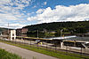 | April 21, 2000 (#00000399) | 830 River Road above Freeport 40°41′09″N 79°39′59″W / 40.685833°N 79.666389°W / 40.685833; -79.666389 (Allegheny River Lock and Dam No. 5) | Gilpin and South Buffalo Townships | |
2 | Allegheny River Lock and Dam No. 6 |  | April 21, 2000 (#00000400) | 1258 River Road above Freeport 40°43′05″N 79°34′46″W / 40.718056°N 79.579444°W / 40.718056; -79.579444 (Allegheny River Lock and Dam No. 6) | Bethel and South Buffalo Townships | |
3 | Allegheny River Lock and Dam No. 7 | 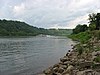 | April 21, 2000 (#00000401) | Along Pennsylvania Route 4023, 0.6 miles (0.97 km) north of Kittanning Bridge 40°49′16″N 79°31′44″W / 40.821111°N 79.528889°W / 40.821111; -79.528889 (Allegheny River Lock and Dam No. 7) | East Franklin Township and Kittanning | |
4 | Allegheny River Lock and Dam No. 8 |  | April 21, 2000 (#00000402) | Along Pennsylvania Route 1033, 1.5 miles (2.4 km) south of Templeton 40°53′48″N 79°28′48″W / 40.896667°N 79.48°W / 40.896667; -79.48 (Allegheny River Lock and Dam No. 8) | Boggs and Washington Townships | |
5 | Allegheny River Lock and Dam No. 9 | 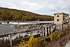 | April 21, 2000 (#00000403) | Terminus of Pennsylvania Route 1004, 0.2 miles (0.32 km) north of Township Route 488 40°57′17″N 79°32′50″W / 40.954722°N 79.547222°W / 40.954722; -79.547222 (Allegheny River Lock and Dam No. 9) | Madison and Washington Townships | |
6 | Armstrong County Courthouse and Jail |  | November 1, 1981 (#81000526) | East Market Street 40°48′59″N 79°31′00″W / 40.816389°N 79.516667°W / 40.816389; -79.516667 (Armstrong County Courthouse and Jail) | Kittanning | |
7 | Bradys Bend Iron Company Furnaces |  | August 11, 1980 (#80003407) | Pennsylvania Route 68 in Bradys Bend 40°59′55″N 79°37′34″W / 40.998611°N 79.626111°W / 40.998611; -79.626111 (Bradys Bend Iron Company Furnaces) | Bradys Bend Township | |
8 | Bridge between Madison and Mahoning Townships |  | June 22, 1988 (#88000798) | Legislative Route 03178 over Mahoning Creek near Deanville 40°55′52″N 79°23′18″W / 40.931111°N 79.388333°W / 40.931111; -79.388333 (Bridge between Madison and Mahoning Townships) | Madison and Mahoning Townships | |
9 | Colwell Cut Viaduct |  | June 22, 1988 (#88000796) | Legislative Route 66 over the Pittsburg and Shawmut Railroad southwest of Seminole 40°56′13″N 79°21′47″W / 40.936944°N 79.363056°W / 40.936944; -79.363056 (Colwell Cut Viaduct) | Mahoning Township | |
10 | Drake Log Cabin |  | March 3, 1983 (#83002214) | Williams Alley 40°34′45″N 79°33′55″W / 40.579056°N 79.565278°W / 40.579056; -79.565278 (Drake Log Cabin) | Apollo | |
11 | Ford City Armory | 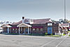 | December 22, 1989 (#89002074) | 301 Tenth Street 40°46′18″N 79°31′55″W / 40.771667°N 79.531944°W / 40.771667; -79.531944 (Ford City Armory) | Ford City | |
12 | Thomas Marshall House |  | April 22, 1976 (#76001602) | State Street 40°52′50″N 79°14′34″W / 40.880556°N 79.242778°W / 40.880556; -79.242778 (Thomas Marshall House) | Dayton | |
13 | St. Patrick's Roman Catholic Church | 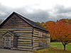 | March 21, 1978 (#78002340) | West of Cowansville off Pennsylvania Route 268 40°53′45″N 79°40′37″W / 40.895833°N 79.676944°W / 40.895833; -79.676944 (St. Patrick's Roman Catholic Church) | Sugarcreek Township | |
14 | St. Stephen's Church | 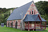 | June 30, 1980 (#80003408) | Pennsylvania Route 68 in Bradys Bend 40°59′40″N 79°37′51″W / 40.994444°N 79.630833°W / 40.994444; -79.630833 (St. Stephen's Church) | Bradys Bend Township |
See also[edit]
| Wikimedia Commons has media related to National Register of Historic Places in Armstrong County, Pennsylvania. |
- List of Pennsylvania state historical markers in Armstrong County
References[edit]
^ The latitude and longitude information provided in this table was derived originally from the National Register Information System, which has been found to be fairly accurate for about 99% of listings. For about 1% of NRIS original coordinates, experience has shown that one or both coordinates are typos or otherwise extremely far off; some corrections may have been made. A more subtle problem causes many locations to be off by up to 150 yards, depending on location in the country: most NRIS coordinates were derived from tracing out latitude and longitudes from USGS topographical quadrant maps created under the North American Datum of 1927, which differs from the current, highly accurate WGS84 GPS system used by most on-line maps. Chicago is about right, but NRIS longitudes in Washington are higher by about 4.5 seconds, and are lower by about 2.0 seconds in Maine. Latitudes differ by about 1.0 second in Florida. Some locations in this table may have been corrected to current GPS standards.
^ "National Register of Historic Places: Weekly List Actions". National Park Service, United States Department of the Interior. Retrieved on March 22, 2019.
^ Numbers represent an ordering by significant words. Various colorings, defined here, differentiate National Historic Landmarks and historic districts from other NRHP buildings, structures, sites or objects.
^ The eight-digit number below each date is the number assigned to each location in the National Register Information System database, which can be viewed by clicking the number.
US National Register of Historic Places in Pennsylvania | ||
|---|---|---|
| Topics |
|   |
| Lists by county |
| |
| Lists by city |
| |
| Other lists |
| |
| ||
Municipalities and communities of Armstrong County, Pennsylvania, United States | ||
|---|---|---|
County seat: Kittanning | ||
| City |
|  |
| Boroughs |
| |
| Townships |
| |
| CDPs |
| |
| Unincorporated communities |
| |
Categories:
- Lists of National Register of Historic Places in Pennsylvania by county
- Armstrong County, Pennsylvania
- National Register of Historic Places in Armstrong County, Pennsylvania
(window.RLQ=window.RLQ||).push(function()mw.config.set("wgPageParseReport":"limitreport":"cputime":"0.380","walltime":"0.491","ppvisitednodes":"value":6312,"limit":1000000,"ppgeneratednodes":"value":0,"limit":1500000,"postexpandincludesize":"value":152837,"limit":2097152,"templateargumentsize":"value":14134,"limit":2097152,"expansiondepth":"value":10,"limit":40,"expensivefunctioncount":"value":1,"limit":500,"unstrip-depth":"value":0,"limit":20,"unstrip-size":"value":2934,"limit":5000000,"entityaccesscount":"value":0,"limit":400,"timingprofile":["100.00% 322.068 1 -total"," 59.02% 190.077 14 Template:NRHP_row"," 12.74% 41.040 21 Template:NRHP_color"," 11.91% 38.347 14 Template:Dts"," 11.71% 37.713 15 Template:Designation/color"," 11.36% 36.580 1 Template:Commons_category"," 9.82% 31.633 14 Template:Coord"," 9.60% 30.915 3 Template:Convert"," 9.30% 29.948 28 Template:First_word"," 8.79% 28.294 2 Template:Navbox"],"scribunto":"limitreport-timeusage":"value":"0.092","limit":"10.000","limitreport-memusage":"value":4711498,"limit":52428800,"cachereport":"origin":"mw1252","timestamp":"20190330204754","ttl":2592000,"transientcontent":false););"@context":"https://schema.org","@type":"Article","name":"National Register of Historic Places listings in Armstrong County, Pennsylvania","url":"https://en.wikipedia.org/wiki/National_Register_of_Historic_Places_listings_in_Armstrong_County,_Pennsylvania","sameAs":"http://www.wikidata.org/entity/Q6975338","mainEntity":"http://www.wikidata.org/entity/Q6975338","author":"@type":"Organization","name":"Contributors to Wikimedia projects","publisher":"@type":"Organization","name":"Wikimedia Foundation, Inc.","logo":"@type":"ImageObject","url":"https://www.wikimedia.org/static/images/wmf-hor-googpub.png","datePublished":"2008-12-07T21:20:22Z","dateModified":"2017-03-02T15:17:20Z","image":"https://upload.wikimedia.org/wikipedia/commons/d/de/Map_of_Pennsylvania_highlighting_Armstrong_County.svg","headline":"Wikimedia list article"(window.RLQ=window.RLQ||).push(function()mw.config.set("wgBackendResponseTime":120,"wgHostname":"mw1325"););


