Rexburg, Idaho
Rexburg, Idaho
Jump to navigation
Jump to search
| Rexburg, Idaho | |
|---|---|
City | |
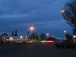 Downtown Rexburg, May 2007 | |
Motto(s): "America's Family Community"[1] | |
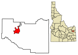 Location of Rexburg in Madison County, Idaho. | |
 Rexburg, Idaho Location in the United States | |
Coordinates: 43°49′N 111°47′W / 43.817°N 111.783°W / 43.817; -111.783Coordinates: 43°49′N 111°47′W / 43.817°N 111.783°W / 43.817; -111.783 | |
| Country | United States |
| State | Idaho |
| County | Madison |
| Area[2] | |
| • Total | 9.78 sq mi (25.32 km2) |
| • Land | 9.70 sq mi (25.12 km2) |
| • Water | 0.08 sq mi (0.21 km2) |
| Elevation | 4,865 ft (1,483 m) |
| Population (2010)[3] | |
| • Total | 25,484 |
| • Estimate (2016)[4] | 28,222 |
| • Density | 2,910.38/sq mi (1,123.70/km2) |
| Time zone | Mountain (MST) (UTC−7) |
| • Summer (DST) | MDT (UTC−6) |
| ZIP codes | 83440, 83441, 83460 |
| Area code(s) | 208 |
| FIPS code | 16-67420 |
GNIS feature ID | 0374648 |
| Website | www.rexburg.org |
Rexburg is a city in Madison County, Idaho, United States. The population was 25,484 at the 2010 census, up from 17,257 in 2000.[5] The city is the county seat of Madison County[6] and its largest city.[7] Rexburg is the principal city of the Rexburg, ID Micropolitan Statistical Area, which includes Fremont and Madison Counties. The city is home to Brigham Young University-Idaho (BYU-Idaho), a private institution operated by The Church of Jesus Christ of Latter-day Saints (LDS Church).
Contents
1 History
2 Geography
3 Climate
4 Demographics
4.1 2010 census
4.2 2000 census
5 Government
5.1 Politics
6 Education
6.1 Public schools
6.2 Higher education
6.3 Madison Memorial Hospital
7 Media
8 Notable people
9 References
10 External links
History[edit]
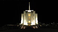
Rexburg Idaho Temple of The Church of Jesus Christ of Latter-day Saints
The city takes its name from founder Thomas Edwin Ricks. The city was incorporated in 1883.[8]
Rexburg was severely damaged by the Teton Dam Flood in June 1976. The Teton River flowed through northern Rexburg, and left most of the city underwater for several days after the Teton Dam ruptured. A museum dedicated to the Teton Dam Flood and the history of Rexburg and the area, located in the basement of the Rexburg Tabernacle, has been a major city landmark for decades.
When the Rexburg Idaho Temple was dedicated in 2008, Rexburg became the third city in Idaho with an LDS temple.[9]
Geography[edit]
Rexburg is located at 43°49′N 111°47′W / 43.817°N 111.783°W / 43.817; -111.783,[10] at an elevation of 4,865 feet (1,483 m) above sea level.
According to the United States Census Bureau, the city has a total area of 9.84 square miles (25.49 km2), of which, 9.76 square miles (25.28 km2) is land and 0.08 square miles (0.21 km2) is water.[11]
Much of the city, including BYU-Idaho and the Rexburg Idaho LDS (Mormon) Temple, rests on top of a shield volcano just north of Rigby, ID. Eruptions are not expected in the near future so far south; Yellowstone National Park and Island Park are thought to be the most likely settings for future volcanic activity in the area. Many different types of volcanoes exist near Rexburg, including cinder cones, spatter cones, other shield volcanoes, and volcanic fissures. There are lava fields to the west and south of Rexburg, the results of open fissure eruptions from about two thousand years ago. The nearby Craters of the Moon National Monument presents the most obvious features of this recent activity. Sediment deposits enriched by volcanism make the surrounding area famous for its production of large starch-rich potatoes.
Rexburg is close to the St. Anthony Sand Dunes, the West Entrance of Yellowstone National Park and the Teton Range.
Climate[edit]
Rexburg experiences a humid continental climate (Köppen climate classification Dfb) with cold winters and hot summers - though even in the summer, nights are chilly and frosts have occurred in all months of the year. The wettest year has been 1983 with 20.76 inches (527.3 mm) and the driest has been 1988 with 7.48 inches (190.0 mm) including rainless months in July and October, though the wettest month was May 1981 with 4.22 inches (107.2 mm). The average snow cover peaks at around 9 inches (22.9 cm), whilst the heaviest snowfall in one month was 43.5 inches (110.5 cm) in December 1983.
| Climate data for Rexburg, Idaho | |||||||||||||
|---|---|---|---|---|---|---|---|---|---|---|---|---|---|
| Month | Jan | Feb | Mar | Apr | May | Jun | Jul | Aug | Sep | Oct | Nov | Dec | Year |
| Record high °F (°C) | 52 (11) | 60 (16) | 73 (23) | 84 (29) | 91 (33) | 102 (39) | 99 (37) | 99 (37) | 94 (34) | 87 (31) | 70 (21) | 61 (16) | 102 (39) |
| Average high °F (°C) | 29.4 (−1.4) | 33.4 (0.8) | 46.3 (7.9) | 57.3 (14.1) | 65.9 (18.8) | 74.6 (23.7) | 83.5 (28.6) | 84.3 (29.1) | 73.9 (23.3) | 60.3 (15.7) | 41.4 (5.2) | 30.3 (−0.9) | 56.7 (13.7) |
| Average low °F (°C) | 10.7 (−11.8) | 13.8 (−10.1) | 23.5 (−4.7) | 30.6 (−0.8) | 38.6 (3.7) | 44.8 (7.1) | 49.2 (9.6) | 47.2 (8.4) | 38.6 (3.7) | 29.9 (−1.2) | 20.2 (−6.6) | 11.4 (−11.4) | 29.9 (−1.2) |
| Record low °F (°C) | −32 (−36) | −36 (−38) | −12 (−24) | 10 (−12) | 16 (−9) | 29 (−2) | 32 (0) | 27 (−3) | 14 (−10) | 6 (−14) | −13 (−25) | −31 (−35) | −36 (−38) |
| Average precipitation inches (mm) | 1.11 (28.2) | 1.02 (25.9) | 1.07 (27.2) | 1.13 (28.7) | 1.89 (48) | 1.44 (36.6) | 0.90 (22.9) | 0.72 (18.3) | 0.82 (20.8) | 1.07 (27.2) | 1.09 (27.7) | 1.06 (26.9) | 13.32 (338.4) |
| Average snowfall inches (cm) | 13.5 (34.3) | 10.5 (26.7) | 4.0 (10.2) | 2.1 (5.3) | 0.5 (1.3) | 0.0 (0) | 0.0 (0) | 0.0 (0) | 0.1 (0.3) | 1.0 (2.5) | 7.6 (19.3) | 15.3 (38.9) | 54.6 (138.8) |
| Average precipitation days (≥ 0.01 inch) | 10 | 8 | 8 | 9 | 11 | 8 | 6 | 6 | 5 | 7 | 8 | 9 | 95 |
| Source: Western Regional Climate Center[12] | |||||||||||||
Demographics[edit]
| Historical population | |||
|---|---|---|---|
| Census | Pop. | %± | |
| 1900 | 1,081 | — | |
| 1910 | 1,893 | 75.1% | |
| 1920 | 3,569 | 88.5% | |
| 1930 | 3,048 | −14.6% | |
| 1940 | 3,437 | 12.8% | |
| 1950 | 4,253 | 23.7% | |
| 1960 | 4,767 | 12.1% | |
| 1970 | 8,272 | 73.5% | |
| 1980 | 11,559 | 39.7% | |
| 1990 | 14,302 | 23.7% | |
| 2000 | 17,257 | 20.7% | |
| 2010 | 25,484 | 47.7% | |
| Est. 2016 | 28,222 | [4] | 10.7% |
| U.S. Decennial Census[13] | |||
City officials have contested the census figures on the grounds that many college students were out of town while census workers were counting Rexburg's population.[14]
Rexburg also has an estimated 95 percent LDS population.[15]
2010 census[edit]
As of the census[3] of 2010, there were 25,484 people, 7,179 households, and 4,925 families residing in the city. The population density was 2,611.1 inhabitants per square mile (1,008.2/km2). There were 7,617 housing units at an average density of 780.4 per square mile (301.3/km2). The racial makeup of the city was 93.8% White, 0.6% African American, 0.2% Native American, 1.2% Asian, 0.2% Pacific Islander, 2.3% from other races, and 1.7% from two or more races. Hispanic or Latino of any race were 5.6% of the population.
There were 7,179 households of which 33.8% had children under the age of 18 living with them, 62.6% were married couples living together, 4.4% had a female householder with no husband present, 1.6% had a male householder with no wife present, and 31.4% were non-families. 9.2% of all households were made up of individuals and 3.5% had someone living alone who was 65 years of age or older. The average household size was 3.41 and the average family size was 3.17.
The median age in the city was 22.3 years. 20.4% of residents were under the age of 18; 49.2% were between the ages of 18 and 24; 19.9% were from 25 to 44; 7% were from 45 to 64; and 3.7% were 65 years of age or older. The gender makeup of the city was 47.3% male and 52.7% female.
2000 census[edit]
As of the census[16] of 2000, there were 17,257 people, 4,274 households, and 2,393 families residing in the city. The population density was 3,534.4 people per square mile (1,365.4/km²). There were 4,533 housing units at an average density of 928.4 per square mile (358.6/km²). The racial makeup of the city was 95.20% White, 0.30% African American, 0.31% Native American, 0.66% Asian, 0.28% Pacific Islander, 2.23% from other races, and 1.03% from two or more races. Hispanic or Latino of any race were 4.04% of the population.
There were 4,274 households out of which 30.5% had children under the age of 18 living with them, 47.7% were married couples living together, 5.9% had a female householder with no husband present, and 44.0% were non-families. 12.7% of all households were made up of individuals and 5.5% had someone living alone who was 65 years of age or older. The average household size was 3.71 and the average family size was 3.45.
In the city, the population was spread out with 18.3% under the age of 18, 57.3% from 18 to 24, 11.9% from 25 to 44, 7.5% from 45 to 64, and 4.9% who were 65 years of age or older. The median age was 20 years. For every 100 females, there were 82.4 males. For every 100 females age 18 and over, there were 77.0 males.
The median income for a household in the city was $26,965, and the median income for a family was $36,047. Males had a median income of $27,280 versus $17,592 for females. The per capita income for the city was $9,173. About 13.2% of families and 44.4% of the population were below the poverty line, including 11.7% of those under age 18 and 12.3% of those age 65 or over.
Government[edit]
Politics[edit]
Rexburg has been referred to as the "reddest place in America,"[17] owing to the area's strong conservative majority and political trends. Some political experts have considered Rexburg, Idaho, the true antithesis of San Francisco, America's liberal bastion.[17] Since 1980, no Republican presidential candidate has won less than 57 percent of the county vote. In that same period, Republican presidential candidates polled more than 90 percent of the county's vote on three occasions: Ronald Reagan in 1984,[18]George W. Bush in 2004[19] and Mitt Romney in 2012.[20]John McCain came close to this level in 2008, drawing 85 percent of the vote.[21]
Education[edit]
Public schools[edit]

Monument located at Brigham Young University-Idaho
The city supports 6 elementary schools; Adams, Burton, Hibbard, Kennedy, Lincoln, and South Fork. Madison Middle School follows the elementary school, serving grades 5-6. Madison Junior High School serves grades 7-9. The only high school within city limits is Madison High School, which has the bobcat as its mascot.
Higher education[edit]
Rexburg is home to BYU-Idaho, a private institution operated by LDS Church. The university began as a small high school-level academy in 1888 and was eventually established as Ricks College, in honor of Mormon pioneer and city founder, Thomas E. Ricks. On August 10, 2001, it officially became a four-year university and assumed the name BYU-Idaho.[22]
Madison Memorial Hospital[edit]
The City of Rexburg and the surrounding areas are serviced by Madison Memorial Hospital located just east of the city's downtown area. The hospital offers regular classes in an attempt to educate the community on such things as preparing for childbirth and first aid for children,[23] as well as holding Conferences and Health Fairs.[24] In 2012 the Leapfrog Group announced the results of a study which indicated that Madison Memorial Hospital is the seventh worst performing hospital in the United States.[25] Madison Memorial declined to participate in the Leapfrog survey, which the hospital says made the survey biased against it.[26] Also in 2012, Rachel Gonzales - Madison's CEO, was ranked amongst the "50 Rural Hospital CEO's to Know" by Becker's Hospital Review.[27] In 2013, Madison was ranked the healthiest county in Idaho.[28] In 2014, the Leapfrog Group shared the results of a study which indicates that Madison Memorial Hospital received an A in comparison to other hospitals in the United States.[29]
Media[edit]
Television
K13UF-D, channel 13 (translator of KPVI-DT Pocatello, ID)
K40KB, channel 40 (translator of KTBN Santa Ana, CA)
K43JD-D, channel 43 (translator of KISU-TV Pocatello, ID)- K51KL, channel 51
Radio
- KBYR 91.5 FM BYU-Idaho Radio (Religious, Radio)
KADQ 100.5 FM (Alternative, Radio)
KIDJ 106.3 FM (Oldies, Radio)
KUPI 99.1 FM (Country, Radio)- KBYI 94.3 FM BYU-Idaho Radio (Public Radio)
KCHQ 102.1 FM (Country)
KFTZ 103.3 FM (Top-40)
KTHK 105.5 FM (Country)
KGTM 98.1 FM ({Hot AC]])
KQEO 107.1 FM (Classic Hits)
KAOX 107.9 FM Top-40
KID 590 AM (News/Talk)- KUPI 980 AM (Oldies)
KRXK 1230 AM (Sports)
KSSL 1260 AM (Talk)
KIGO 1400 AM (Spanish)
Newspapers
- Rexburg Standard Journal
- Scroll
- Topix
Notable people[edit]
James LeVoy Sorenson, businessman and inventor.
Brandon Bair, defensive end for NFL's Oakland Raiders
Christian Jacobs, co-creator of children's TV show Yo Gabba Gabba! and lead singer for The Aquabats[30]
Jim Dennis, Hall of Fame harness racing driver.
Vernon M. Guymon, Brigadier general in the Marine Corps and Naval Aviator
Paul Kruger, linebacker for NFL's Cleveland Browns
Matt Lindstrom, Major League Baseball pitcher for Chicago White Sox
Clayton Mortensen, Major League Baseball pitcher for Boston Red Sox
Mark Ricks, Idaho state legislator
Wayne D. Wright, jockey, winner of 1942 Kentucky Derby, 1945 Preakness and 1934 Belmont Stakes
References[edit]
^ "City of Rexburg, Idaho". City of Rexburg, Idaho. Retrieved September 2, 2012.
^ "2016 U.S. Gazetteer Files". United States Census Bureau. Retrieved Jul 26, 2017.
^ ab "American FactFinder". United States Census Bureau. Retrieved 2012-12-18.
^ ab "Population and Housing Unit Estimates". Retrieved June 9, 2017.
^ "Quickfacts: Rexburg, Idaho". United States Census Bureau, Population Division. 2010. Retrieved 2011-12-11.
^ "Find a County". National Association of Counties. Retrieved 2011-06-07.
^ "Profile for Rexburg, Idaho, ID". ePodunk. Retrieved September 2, 2012.
^ "Rexburg, Idaho". City-Data.com. Retrieved September 2, 2012.
^ "404 Not found". Archived from the original on 6 October 2014. Retrieved 2 October 2014.
^ "US Gazetteer files: 2010, 2000, and 1990". United States Census Bureau. 2011-02-12. Retrieved 2011-04-23.
^ "US Gazetteer files 2010". United States Census Bureau. Archived from the original on 2012-01-24. Retrieved 2012-12-18.
^ REXBURG RICKS COLLEGE, IDAHO (107644). Retrieved 22 April 2013.
^ "Census of Population and Housing". Census.gov. Retrieved June 4, 2015.
^ "BYU-Idaho student count at root of Rexburg's census challenge". Standard Journal. Retrieved 2 October 2014.
^ "LDS Church News - Rexburg: 'unique in all the world'". Retrieved 2 October 2014.
^ "American FactFinder". United States Census Bureau. Retrieved 2008-01-31.
^ ab "The reddest place in America". Retrieved 2 October 2014.
^ "Dave Leip's Atlas of U.S. Presidential Elections". Retrieved 2 October 2014.
^ "Dave Leip's Atlas of U.S. Presidential Elections". Retrieved 2 October 2014.
^ "Dave Leip's Atlas of U.S. Presidential Elections - State Data". Retrieved 2 October 2014.
^ "Dave Leip's Atlas of U.S. Presidential Elections". Retrieved 2 October 2014.
^ http://www.byui.edu/pr/general/byuihistory.htm
^ http://www.madisonhospital.org/services/education-classes.html[permanent dead link]
^ "Women's Health Conference Madison". madisonmemorial.org. Retrieved 18 May 2015.
^ "25 Worst Hospitals in the U.S. Is Yours On the List?". Health News / Tips & Trends / Celebrity Health. Retrieved 2 October 2014.
^ "Madison Memorial named one of 25 worst hospitals". Standard Journal. Archived from the original on 12 April 2014. Retrieved 2 October 2014.
^ Heather Punke. "50 Rural Hospital CEOs to Know". beckershospitalreview.com. Retrieved 18 May 2015.
^ KTVB, KTVB.COM (21 March 2013). "Report ranks Madison County as Idaho's healthiest". Archived from the original on 4 March 2016. Retrieved 2 October 2014.
^ "Madison Memorial receives 'A'". Standard Journal. Retrieved 18 May 2015.
^ "Christian Jacobs". Internet Movie Database. Retrieved September 2, 2012.
External links[edit]
 Media related to Rexburg, Idaho at Wikimedia Commons
City of Rexburg, Idaho Website Portal style website, Government, Business, Library, Recreation and more
Municipalities and communities of Madison County, Idaho, United States | ||
|---|---|---|
County seat: Rexburg | ||
| Cities |
| |
| Unincorporated communities |
| |
Boise (capital) | ||
| Topics |
|  Seal of Idaho |
| Society |
| |
| Regions |
| |
| Larger cities |
| |
| Smaller cities |
| |
| Counties |
| |
Categories:
- Cities in Idaho
- Cities in Madison County, Idaho
- County seats in Idaho
- Rexburg, Idaho micropolitan area
- University towns in the United States
- Populated places established in 1883
- 1883 establishments in Idaho Territory
(window.RLQ=window.RLQ||).push(function()mw.config.set("wgPageParseReport":"limitreport":"cputime":"0.656","walltime":"0.826","ppvisitednodes":"value":7148,"limit":1000000,"ppgeneratednodes":"value":0,"limit":1500000,"postexpandincludesize":"value":146363,"limit":2097152,"templateargumentsize":"value":17543,"limit":2097152,"expansiondepth":"value":22,"limit":40,"expensivefunctioncount":"value":2,"limit":500,"unstrip-depth":"value":0,"limit":20,"unstrip-size":"value":29040,"limit":5000000,"entityaccesscount":"value":1,"limit":400,"timingprofile":["100.00% 668.479 1 -total"," 43.04% 287.743 1 Template:Infobox_settlement"," 25.71% 171.887 1 Template:Reflist"," 25.07% 167.568 1 Template:Infobox"," 17.51% 117.049 27 Template:Cite_web"," 8.94% 59.742 1 Template:Weather_box"," 8.91% 59.547 1 Template:Short_description"," 7.56% 50.550 7 Template:Both"," 7.41% 49.548 2 Template:Coord"," 5.95% 39.789 1 Template:Madison_County,_Idaho"],"scribunto":"limitreport-timeusage":"value":"0.247","limit":"10.000","limitreport-memusage":"value":9688460,"limit":52428800,"cachereport":"origin":"mw1328","timestamp":"20180831193550","ttl":1900800,"transientcontent":false);mw.config.set("wgBackendResponseTime":924,"wgHostname":"mw1328"););

 Clash Royale CLAN TAG

