Kerry, Queensland
Kerry, Queensland
Jump to navigation
Jump to search
Kerry Queensland | |||||||||||||||
|---|---|---|---|---|---|---|---|---|---|---|---|---|---|---|---|
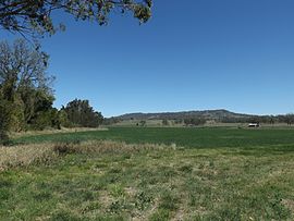
 Fields along Albert River, 2014 | |||||||||||||||
 Kerry | |||||||||||||||
| Coordinates | 28°6′S 153°1′E / 28.100°S 153.017°E / -28.100; 153.017Coordinates: 28°6′S 153°1′E / 28.100°S 153.017°E / -28.100; 153.017 | ||||||||||||||
| Population | 433 (2011 census)[1] | ||||||||||||||
| Postcode(s) | 4285 | ||||||||||||||
| LGA(s) | Scenic Rim Region | ||||||||||||||
| State electorate(s) | Scenic Rim | ||||||||||||||
| Federal Division(s) | Wright | ||||||||||||||
| |||||||||||||||
Kerry is a locality in the Scenic Rim Region of South East Queensland, Australia. At the 2011 Australian Census Kerry recorded a population of 433.[1]
Contents
1 History
2 Heritage listings
3 Notable people
4 Demographics
5 References
6 External links
History[edit]
Kerry Post Office opened on 1 July 1927 and closed in 1939.[2]
Heritage listings[edit]
Kerry has the following heritage-listed sites:
- 1823 Kerry Road: St John’s Catholic Church and Cemetery [3]
Notable people[edit]

Bernard O'Reilly headstone, St Johns Catholic Church, Kerry
Bernard O'Reilly, the bushman and author is buried in St John's Catholic Church cemetery
Demographics[edit]
In the 2011 census, Kerry recorded a population of 433 people, 48.7% female and 51.3% male.[1] The median age of the Kerry population was 44 years, 7 years above the national median of 37. 87.9% of people living in Kerry were born in Australia. The other top responses for country of birth were England 2.1%, New Zealand 1.2%, Germany 0.7%, Ireland 0.7%, Belgium 0.7%. 93.5% of people spoke only English at home; the next most common languages were 0.7% Indonesian, 0.7% Spanish.[1]
References[edit]
^ abcd Australian Bureau of Statistics (31 October 2012). "Kerry (State Suburb)". 2011 Census QuickStats. Retrieved 17 August 2014..mw-parser-output cite.citationfont-style:inherit.mw-parser-output qquotes:"""""""'""'".mw-parser-output code.cs1-codecolor:inherit;background:inherit;border:inherit;padding:inherit.mw-parser-output .cs1-lock-free abackground:url("//upload.wikimedia.org/wikipedia/commons/thumb/6/65/Lock-green.svg/9px-Lock-green.svg.png")no-repeat;background-position:right .1em center.mw-parser-output .cs1-lock-limited a,.mw-parser-output .cs1-lock-registration abackground:url("//upload.wikimedia.org/wikipedia/commons/thumb/d/d6/Lock-gray-alt-2.svg/9px-Lock-gray-alt-2.svg.png")no-repeat;background-position:right .1em center.mw-parser-output .cs1-lock-subscription abackground:url("//upload.wikimedia.org/wikipedia/commons/thumb/a/aa/Lock-red-alt-2.svg/9px-Lock-red-alt-2.svg.png")no-repeat;background-position:right .1em center.mw-parser-output .cs1-subscription,.mw-parser-output .cs1-registrationcolor:#555.mw-parser-output .cs1-subscription span,.mw-parser-output .cs1-registration spanborder-bottom:1px dotted;cursor:help.mw-parser-output .cs1-hidden-errordisplay:none;font-size:100%.mw-parser-output .cs1-visible-errorfont-size:100%.mw-parser-output .cs1-subscription,.mw-parser-output .cs1-registration,.mw-parser-output .cs1-formatfont-size:95%.mw-parser-output .cs1-kern-left,.mw-parser-output .cs1-kern-wl-leftpadding-left:0.2em.mw-parser-output .cs1-kern-right,.mw-parser-output .cs1-kern-wl-rightpadding-right:0.2em
^ Premier Postal History. "Post Office List". Premier Postal Auctions. Retrieved 10 May 2014.
^ "Local Heritage Register" (PDF). Scenic Rim Regional Council. Retrieved 9 February 2015.
External links[edit]
![]() Media related to Kerry, Queensland at Wikimedia Commons
Media related to Kerry, Queensland at Wikimedia Commons
This Queensland location article is a stub. You can help Wikipedia by expanding it. |
Categories:
- Towns in Queensland
- Scenic Rim Region
- Queensland geography stubs
(window.RLQ=window.RLQ||).push(function()mw.config.set("wgPageParseReport":"limitreport":"cputime":"0.340","walltime":"0.482","ppvisitednodes":"value":1528,"limit":1000000,"ppgeneratednodes":"value":0,"limit":1500000,"postexpandincludesize":"value":56606,"limit":2097152,"templateargumentsize":"value":6637,"limit":2097152,"expansiondepth":"value":12,"limit":40,"expensivefunctioncount":"value":3,"limit":500,"unstrip-depth":"value":1,"limit":20,"unstrip-size":"value":9022,"limit":5000000,"entityaccesscount":"value":1,"limit":400,"timingprofile":["100.00% 407.360 1 -total"," 39.24% 159.846 1 Template:Infobox_Australian_place"," 28.31% 115.332 1 Template:Reflist"," 23.60% 96.152 1 Template:Infobox"," 21.31% 86.792 1 Template:Census_2011_AUS"," 20.56% 83.752 3 Template:Cite_web"," 14.40% 58.653 1 Template:Commons_category-inline"," 8.77% 35.714 1 Template:Short_description"," 8.54% 34.794 1 Template:Use_dmy_dates"," 8.16% 33.240 1 Template:Coord"],"scribunto":"limitreport-timeusage":"value":"0.154","limit":"10.000","limitreport-memusage":"value":4869479,"limit":52428800,"cachereport":"origin":"mw1242","timestamp":"20181213031612","ttl":1900800,"transientcontent":false);mw.config.set("wgBackendResponseTime":101,"wgHostname":"mw1244"););

