Centre County, Pennsylvania
Centre County, Pennsylvania
Jump to navigation
Jump to search
Centre County, Pennsylvania | ||
|---|---|---|
 The Centre County Courthouse in Bellefonte | ||
| ||
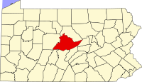 Location within the U.S. state of Pennsylvania | ||
 Pennsylvania's location within the U.S. | ||
| Founded | February 13, 1800 | |
| Named for | Its location in the center of the state | |
| Seat | Bellefonte | |
| Largest borough | State College | |
| Area | ||
| • Total | 1,113 sq mi (2,883 km2) | |
| • Land | 1,110 sq mi (2,875 km2) | |
| • Water | 3.0 sq mi (8 km2), 0.3% | |
| Population (est.) | ||
| • (2017) | 162,660 | |
| • Density | 145/sq mi (56/km2) | |
| Congressional districts | 12th, 15th | |
| Time zone | Eastern: UTC−5/−4 | |
| Website | www.centrecountypa.gov | |
Footnotes: | ||
Pennsylvania Historical Marker | ||
| Designated | May 10, 1982[1] | |

Centre County is a county in the U.S. state of Pennsylvania. As of the 2010 census, the population was 153,990.[2] Its county seat is Bellefonte.[3] Centre County comprises the State College, PA Metropolitan Statistical Area.
Contents
1 History
2 Geography
2.1 Features
2.2 Adjacent counties
3 Demographics
4 Metropolitan Statistical Area
5 Law and government
5.1 County Commissioners
5.2 Other county offices
5.3 State Senate[15]
5.4 State House of Representatives[15]
5.5 United States House of Representatives
5.6 United States Senate
6 Politics
7 Education
7.1 Colleges and universities
7.2 Community, junior, and technical colleges
7.3 Public school districts
7.4 Public charter schools
7.5 Private schools
7.6 Libraries
7.6.1 Pennsylvania State University libraries
8 Transportation
8.1 Major highways
9 Recreation
10 Media
11 Communities
11.1 Home rule municipalities
11.2 Boroughs
11.3 Townships
11.4 Census-designated places
11.5 Unincorporated communities
11.6 Population ranking
12 See also
13 References
14 External links
History[edit]
The lands of the future Centre County were first recorded by James Potter in 1764. Potter, having reached the top of Nittany Mountain, and "....seeing the prairies and noble forest beneath him, cried out to his attendant, 'By heavens, Thompson, I have discovered an empire!'" [4] After the American Revolutionary War, Centre County was created on February 13, 1800, from parts of Huntingdon, Lycoming, Mifflin, and Northumberland counties; it was named for its central location in the state.
Geography[edit]
According to the U.S. Census Bureau, the county has a total area of 1,113 square miles (2,880 km2), of which 1,110 square miles (2,900 km2) is land and 3.0 square miles (7.8 km2) (0.3%) is water.[5] It is the fifth-largest county in Pennsylvania by area.
Features[edit]
- Bald Eagle Valley
- Bald Eagle Mountain
- Nittany Valley
- Mount Nittany
- Penns Valley
- Tussey Mountain
Adjacent counties[edit]
Clinton County (north)
Union County (east)
Mifflin County (southeast)
Huntingdon County (south)
Blair County (south)
Clearfield County (west)
Demographics[edit]
| Historical population | |||
|---|---|---|---|
| Census | Pop. | %± | |
| 1810 | 10,681 | — | |
| 1820 | 13,796 | 29.2% | |
| 1830 | 18,879 | 36.8% | |
| 1840 | 20,492 | 8.5% | |
| 1850 | 23,355 | 14.0% | |
| 1860 | 27,000 | 15.6% | |
| 1870 | 34,418 | 27.5% | |
| 1880 | 37,922 | 10.2% | |
| 1890 | 43,269 | 14.1% | |
| 1900 | 42,894 | −0.9% | |
| 1910 | 43,424 | 1.2% | |
| 1920 | 44,304 | 2.0% | |
| 1930 | 46,294 | 4.5% | |
| 1940 | 52,608 | 13.6% | |
| 1950 | 65,922 | 25.3% | |
| 1960 | 78,580 | 19.2% | |
| 1970 | 99,267 | 26.3% | |
| 1980 | 112,760 | 13.6% | |
| 1990 | 123,786 | 9.8% | |
| 2000 | 135,760 | 9.7% | |
| 2010 | 153,990 | 13.4% | |
| Est. 2017 | 162,660 | [6] | 5.6% |
| U.S. Decennial Census[7] 1790-1960[8] 1900-1990[9] 1990-2000[10] 2010-2017[2] | |||
As of the census[11] of 2010, there were 153,990 people, 57,573 households, and 31,256 families residing in the county. The population density was 139 people per square mile (54/km²). There were 63,297 housing units at an average density of 57 per square mile (22/km²). The racial makeup of the county was 89.4% White, 3.0% Black or African American, 0.1% Native American, 5.2% Asian, 0.1% Pacific Islander, 0.7% from other races, and 1.5% from two or more races. 2.4% of the population were Hispanic or Latino of any race.
There were 57,573 households out of which 23.3% had children under the age of 18 living with them, 44.6% were married couples living together, 3.3% had a male householder with no wife present, 6.4% had a female householder with no husband present, and 45.7% were non-families. 28.7% of all households were made up of individuals and 8.3% had someone living alone who was 65 years of age or older. The average household size was 2.38 and the average family size was 2.91.
In the county, the population was spread out with 15.9% under the age of 18, 28.9% from 18 to 24, 22.6% from 25 to 44, 21.3% from 45 to 64, and 11.3% who were 65 years of age or older. The median age was 29 years. For every 100 females there were 107.5 males. For every 100 females age 18 and over, there were 108.1 males.
Metropolitan Statistical Area[edit]

Map of the State College-DuBois, PA Combined Statistical Area (CSA), composed of the following parts:
State College, PA Metropolitan Statistical Area
DuBois, PA Micropolitan Statistical Area
The United States Office of Management and Budget[12] has designated Centre County as the State College, PA Metropolitan Statistical Area (MSA). As of the 2010 U.S. Census[13] the metropolitan area ranked 13th most populous in the State of Pennsylvania and the 259th most populous in the United States with a population of 155,403. Centre County is also a part of the larger State College-DuBois, PA Combined Statistical Area (CSA), which combines the populations of Centre County as well as Clearfield County to the west. The Combined Statistical Area ranked 9th in the State of Pennsylvania and 123rd most populous in the United States with a population of 236,577.
Law and government[edit]
County Commissioners[edit]
- Michael Pipe, Chairman (Democrat)
- Mark Higgins, Vice-Chair (Democrat)
- Steven G. Dershem, Commissioner (Republican) [14]
Other county offices[edit]
Clerk of Courts and Prothonotary, Debra Immel, Democrat
Controller, Charles Witmer, Republican
Coroner, Scott Sayers, Democrat
District Attorney, Stacy Parks Miller, Democrat
Recorder of Deeds, Joe Davidson, Republican- Register of Wills, Christine Millinder, Republican
Sheriff, Bryan Sampsel, Republican
Treasurer, Rich Fornicola, Republican
State Senate[15][edit]
Jake Corman, Republican, Pennsylvania's 34th Senatorial District
State House of Representatives[15][edit]
Michael K. Hanna, Sr., Democrat, Pennsylvania's 76th Representative District
Scott Conklin, Democrat, Pennsylvania's 77th Representative District
Rich Irvin, Republican, Pennsylvania's 81st Representative District
Kerry Benninghoff, Republican, Pennsylvania's 171st Representative District
United States House of Representatives[edit]
Tom Marino, Republican, Pennsylvania's 12th congressional district
Glenn "G.T." Thompson, Republican, Pennsylvania's 15th congressional district
United States Senate[edit]
Pat Toomey, Republican
Bob Casey, Jr., Democrat
Politics[edit]
| Year | Republican | Democratic | Third parties |
|---|---|---|---|
2016 | 45.6% 35,274 | 48.0% 37,088 | 6.4% 4,945 |
2012 | 48.7% 34,001 | 48.9% 34,176 | 2.5% 1,709 |
2008 | 43.4% 32,992 | 55.1% 41,950 | 1.5% 1,169 |
2004 | 51.5% 33,133 | 47.7% 30,733 | 0.8% 508 |
2000 | 52.8% 26,172 | 43.2% 21,409 | 4.0% 1,994 |
1996 | 44.7% 20,935 | 45.2% 21,145 | 10.1% 4,746 |
1992 | 40.0% 20,478 | 41.3% 21,177 | 18.7% 9,570 |
1988 | 56.1% 23,875 | 43.2% 18,357 | 0.7% 295 |
1984 | 62.9% 27,802 | 36.6% 16,194 | 0.5% 240 |
1980 | 48.3% 20,605 | 37.5% 15,987 | 14.2% 6,039 |
1976 | 52.4% 21,177 | 44.2% 17,867 | 3.4% 1,393 |
1972 | 60.5% 20,683 | 38.6% 13,194 | 0.9% 320 |
1968 | 55.6% 15,865 | 39.1% 11,163 | 5.3% 1,499 |
1964 | 36.2% 9,481 | 63.2% 16,556 | 0.6% 158 |
1960 | 68.0% 18,357 | 31.9% 8,601 | 0.2% 46 |
1956 | 67.2% 15,412 | 32.6% 7,483 | 0.2% 45 |
1952 | 66.3% 14,700 | 33.3% 7,391 | 0.4% 77 |
1948 | 61.5% 10,416 | 38.5% 6,515 | |
1944 | 55.1% 10,048 | 44.2% 8,064 | 0.7% 130 |
1940 | 51.8% 10,665 | 47.9% 9,869 | 0.4% 76 |
1936 | 45.2% 9,869 | 53.8% 11,734 | 1.0% 211 |
1932 | 52.6% 8,264 | 44.9% 7,053 | 2.6% 409 |
1928 | 77.2% 12,005 | 22.1% 3,431 | 0.8% 121 |
1924 | 59.1% 7,723 | 34.0% 4,443 | 6.9% 896 |
1920 | 57.8% 7,615 | 36.3% 4,783 | 5.9% 773 |
1916 | 50.0% 4,392 | 46.9% 4,120 | 3.1% 269 |
1912 | 19.0% 1,507 | 43.5% 3,445 | 37.5% 2,974 |
1908 | 53.1% 4,927 | 43.1% 3,998 | 3.8% 351 |
1904 | 55.2% 5,291 | 41.9% 4,015 | 3.0% 283 |
1900 | 50.6% 4,684 | 46.9% 4,339 | 2.4% 226 |
1896 | 49.9% 4,880 | 46.5% 4,546 | 3.6% 348 |
1892 | 42.7% 3,698 | 53.4% 4,624 | 3.9% 334 |
1888 | 48.3% 4,574 | 49.8% 4,712 | 2.0% 185 |
As of November 2014, there were 108,316 registered voters in Centre County.[17]
Democratic: 44,051 (40.67%)
Republican: 41,771 (38.56%)
Libertarian: 685 (0.63%)- No party affiliation: 19,162 (17.69%)
- Other: 2,647 (2.44%)
Centre County had for many years been a strongly Republican county, like most of rural Pennsylvania. In the early 21st century, however, it has been more competitive. In 2000 George W. Bush defeated Al Gore with 52% of the vote to Gore's 43%. In 2004 Bush won the county by a much smaller margin. Bush won 51% to Kerry's 47%, a margin of only 4%. In 2006, Governor Ed Rendell and Bob Casey Jr. both carried Centre, and Democrat Scott Conklin decisively won the State House seat left open by the retirement of Republican Lynn Herman in the 77th district. In 2008, the Democrats captured the countywide registration edge, Barack Obama carried the county with 55% of the vote to McCain's 44%, and Democratic statewide winners (Rob McCord for Treasurer and Jack Wagner for Auditor General also carried Centre.
Analysts believe that many of the students and faculty at the main campus of Penn State, in State College in the southern half of the county, have contributed to the Democratic victories. In 2012, Barack Obama won the county in his reelection campaign by a very narrow margin, 48.9% to 48.65%, a difference of just 175 votes.[18] In 2016, Democrat Hillary Clinton, beat eventual President-elect Republican Donald Trump 47.76% to 45.86%. [19] In that same election, incumbent Republican Senator Pat Toomey beat Democratic opponent Katie McGinty 47.91% to 46.2% in the county.[19]
Education[edit]
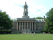
Old Main, the main administrative building of Penn State, at University Park.
Colleges and universities[edit]
- Pennsylvania State University
Community, junior, and technical colleges[edit]
- South Hills School of Business & Technology
Central Pennsylvania Institute of Science and Technology, public Vo Tech in Pleasant Gap
Public school districts[edit]

Map of Centre County, Pennsylvania Public School Districts
- Bald Eagle Area School District
- Bellefonte Area School District
Keystone Central School District (also in Clinton County)- Penns Valley Area School District
Philipsburg-Osceola Area School District (also in Clearfield County)- State College Area School District
Tyrone Area School District (also in Blair County and Huntingdon County)
Public charter schools[edit]
- Young Scholars of Central PA Charter School
- Centre Learning Community Charter School
- Nittany Valley Charter School
- Wonderland Charter School
- There are 13 public cyber charter schools in Pennsylvania that are available for free statewide, to children K-12. See: Education in Pennsylvania.
Private schools[edit]
As reported by the Pennsylvania Department of Education 2010.
- Bower Hollow Parochial School - Woodward
Centre County Christian Academy - Bellefonte- Elk Creek School - Rebersburg
- Faith Christian Academy - Philipsburg
- Grace Prep - State College
- Hill Side School - Rebersburg
- Hubler Ridge School - Bellefonte
- Kramer Gap School - Spring Mills
- Little Nittany Amish Parochial School - Howard
- Mountain View School - Rebersburg
- Nittany Christian School - State College
- Our Lady of Victory School - State College
- Peach Lane Amish School - Madisonburg
- Penns Valley Amish Paroch School - Woodward
- Rockville School - Rebersburg
- Spring Bank School - Rebersburg
- St John Evangelist School - Bellefonte
- St. Joseph's Academy - Boalsburg
- State College Friends School - State College
- Sunny Meadow Parochial School - Howard
- Sunset View School - Howard
- Sunset View School - Rebersburg
- Windy Poplars School - Centre Hall
- Woodside Amish School - Spring Mills
Libraries[edit]
Centre County Libraries- Centre County Library & Historical Museum - Bellefonte
- Centre Hall Area Branch Library - Centre Hall
- Holt Memorial Library - Philipsburg
- Centre County Bookmobile
- American Philatelic Research Library
- Schlow Centre Region Library
Pennsylvania State University libraries[edit]
- Pattee Library
- Paterno Library
- Architecture and Landscape Architecture Library
- Earth and Mineral Sciences Library
- Engineering Library
- Physical and Mathematical Sciences Library
Transportation[edit]
Major highways[edit]
 I-80
I-80 I-99
I-99 US 322

 US 322 Bus.
 US 220
 US 220 Alt.
 PA 26
PA 26 PA 45
PA 45 PA 64
PA 64 PA 144
 PA 150
 PA 192
Recreation[edit]
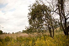
An apple tree and meadow at Bald Eagle State Park
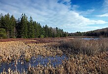
Black Moshannon State Park
There are six Pennsylvania state parks in Centre County.
Bald Eagle State Park is the largest state park in Centre County with 5,900-acres (2,388 ha). It is on Pennsylvania Route 150 between Milesburg and Lock Haven.
Black Moshannon State Park west of State College has a bog with three species of carnivorous plants and 17 orchid varieties.
McCalls Dam State Park is a small park on a dirt road in the extreme eastern tip of the county.
Penn-Roosevelt State Park is the site of a former segregated CCC camp for African American men.
Poe Paddy State Park is at the confluence of Big Poe Creek and Penns Creek.
Poe Valley State Park is in an isolated valley surrounding 25 acre Poe Lake.
Media[edit]
Centre County's main daily newspaper is the Centre Daily Times (part of the McClatchy Company chain). Alternative newspapers include the Centre County Gazette and State College City Guide. Newspapers of Pennsylvania State University's main campus include The Forum and the student-run Daily Collegian.[20]
Numerous magazines are also published including Town & Gown,[21]State College Magazine,[22]Good Life in Happy Valley,[23]Blue White Illustrated, Pennsylvania Business Central, and Voices of Central Pennsylvania.[24]
The radio market of Centre County is ranked #257 in the nation. Some of the more popular stations include WPSU, WKPS, WMAJ, WQWK, WFGE, WBHV, WZWW, WRSC, WAPY, and WBUS.
Centre County is part of the Johnstown/Altoona/State College television market, which is currently ranked #99 in the nation. Television stations broadcasting out of State College include WPSU (PBS) and WHVL (MyNetworkTV) as well as C-NET, Centre County's Government and Education Access Television Network, which broadcasts on two channels: CGTV (Government Access TV) and CETV (Educational Access TV). Johnstown-based WJAC-TV (NBC) and Altoona-based WTAJ-TV (CBS) also maintain satellite studios and offices here.
Communities[edit]

Map of Centre County, Pennsylvania with Municipal Labels showing Boroughs (red), Townships (white), and Census-designated places (blue).
Under Pennsylvania law, there are five types of incorporated municipalities: cities, home rule municipalities, boroughs, townships, and, in at most two cases, towns. The following municipalities, boroughs and townships are in Centre County:
Home rule municipalities[edit]
- Ferguson Township
- State College
Boroughs[edit]
Bellefonte (county seat)- Centre Hall
- Howard
- Milesburg
- Millheim
- Philipsburg
- Port Matilda
- Snow Shoe
- Unionville
Townships[edit]
- Benner
- Boggs
- Burnside
- College
- Curtin
- Gregg
- Haines
- Halfmoon
- Harris
- Howard
- Huston
- Liberty
- Marion
- Miles
- Patton
- Penn
- Potter
- Rush
- Snow Shoe
- Spring
- Taylor
- Union
- Walker
- Worth
Census-designated places[edit]
Census-designated places are geographical areas designated by the U.S. Census Bureau for the purposes of compiling demographic data. They are not actual jurisdictions under Pennsylvania law. Other unincorporated communities, such as villages, may be listed here as well.
- Aaronsburg
- Baileyville
- Blanchard
- Boalsburg
- Clarence
- Coburn
- Eagleville
- Houserville
- Hublersburg
- Jacksonville
- Julian
- Lemont
- Madisonburg
- Mingoville
- Monument
- Moshannon
- Mount Eagle
- Nittany
- North Philipsburg
- Orviston
- Park Forest Village
- Pine Glen
- Pine Grove Mills
- Pleasant Gap
- Ramblewood
- Rebersburg
- Sandy Ridge
- South Philipsburg
- Snydertown
- Spring Mills
- Stormstown
- Toftrees
- Woodward
- Zion
Unincorporated communities[edit]
- Colyer
- Fishermans Paradise
Ingleby (ghost town)- Potter's Mills
- Tusseyville
Population ranking[edit]
The population ranking of the following table is based on the 2010 census of Centre County.[13]
† county seat
| Rank | City/Town/etc. | Municipal type | Population (2010 Census) |
|---|---|---|---|
| 1 | State College | Borough | 42,034 |
| 2 | Park Forest Village | CDP | 9,660 |
| 3 | † Bellefonte | Borough | 6,187 |
| 4 | Boalsburg | CDP | 3,722 |
| 5 | Pleasant Gap | CDP | 2,879 |
| 6 | Philipsburg | Borough | 2,770 |
| 7 | Stormstown | CDP | 2,366 |
| 8 | Lemont | CDP | 2,270 |
| 9 | Toftrees | CDP | 2,053 |
| 10 | Zion | CDP | 2,030 |
| 11 | Houserville | CDP | 1,814 |
| 12 | Pine Grove Mills | CDP | 1,502 |
| 13 | Centre Hall | Borough | 1,265 |
| 14 | Milesburg | Borough | 1,123 |
| 15 | Millheim | Borough | 904 |
| 16 | Ramblewood | CDP | 849 |
| 17 | Snow Shoe | Borough | 765 |
| 18 | Blanchard | CDP | 740 |
| 19 | Howard | Borough | 720 |
| 20 | North Philipsburg | CDP | 660 |
| 21 | Nittany | CDP | 658 |
| 22 | Clarence | CDP | 626 |
| 23 | Aaronsburg | CDP | 613 |
| 24 | Port Matilda | Borough | 606 |
| 25 | Mingoville | CDP | 503 |
| 26 | Rebersburg | CDP | 494 |
| 27 | Snydertown | CDP | 483 |
| 28 | South Philipsburg | CDP | 410 |
| 29 | Sandy Ridge | CDP | 407 |
| 30 | Eagleville | CDP | 324 |
| 31 | Unionville | Borough | 291 |
| 32 | Moshannon | CDP | 281 |
| 33 | Spring Mills | CDP | 268 |
| 34 | Coburn | CDP | 236 |
| 35 | Baileyville | CDP | 201 |
| 36 | Pine Glen | CDP | 190 |
| 37 | Madisonburg | CDP | 168 |
| 38 | Julian | CDP | 152 |
| 39 | Monument | CDP | 150 |
| 40 | Woodward | CDP | 110 |
| 41 | Hublersburg | CDP | 104 |
| 42 | Mount Eagle | CDP | 103 |
| T-43 | Jacksonville | CDP | 95 |
| T-43 | Orviston | CDP | 95 |
See also[edit]
- National Register of Historic Places listings in Centre County, Pennsylvania
References[edit]
^ "PHMC Historical Markers Search" (Searchable database). Pennsylvania Historical and Museum Commission. Commonwealth of Pennsylvania. Retrieved January 25, 2014..mw-parser-output cite.citationfont-style:inherit.mw-parser-output .citation qquotes:"""""""'""'".mw-parser-output .citation .cs1-lock-free abackground:url("//upload.wikimedia.org/wikipedia/commons/thumb/6/65/Lock-green.svg/9px-Lock-green.svg.png")no-repeat;background-position:right .1em center.mw-parser-output .citation .cs1-lock-limited a,.mw-parser-output .citation .cs1-lock-registration abackground:url("//upload.wikimedia.org/wikipedia/commons/thumb/d/d6/Lock-gray-alt-2.svg/9px-Lock-gray-alt-2.svg.png")no-repeat;background-position:right .1em center.mw-parser-output .citation .cs1-lock-subscription abackground:url("//upload.wikimedia.org/wikipedia/commons/thumb/a/aa/Lock-red-alt-2.svg/9px-Lock-red-alt-2.svg.png")no-repeat;background-position:right .1em center.mw-parser-output .cs1-subscription,.mw-parser-output .cs1-registrationcolor:#555.mw-parser-output .cs1-subscription span,.mw-parser-output .cs1-registration spanborder-bottom:1px dotted;cursor:help.mw-parser-output .cs1-ws-icon abackground:url("//upload.wikimedia.org/wikipedia/commons/thumb/4/4c/Wikisource-logo.svg/12px-Wikisource-logo.svg.png")no-repeat;background-position:right .1em center.mw-parser-output code.cs1-codecolor:inherit;background:inherit;border:inherit;padding:inherit.mw-parser-output .cs1-hidden-errordisplay:none;font-size:100%.mw-parser-output .cs1-visible-errorfont-size:100%.mw-parser-output .cs1-maintdisplay:none;color:#33aa33;margin-left:0.3em.mw-parser-output .cs1-subscription,.mw-parser-output .cs1-registration,.mw-parser-output .cs1-formatfont-size:95%.mw-parser-output .cs1-kern-left,.mw-parser-output .cs1-kern-wl-leftpadding-left:0.2em.mw-parser-output .cs1-kern-right,.mw-parser-output .cs1-kern-wl-rightpadding-right:0.2em
^ ab "State & County QuickFacts". United States Census Bureau. Retrieved November 16, 2013.
^ "Find a County". National Association of Counties. Archived from the original on May 31, 2011. Retrieved June 7, 2011.
^ "Centre County Pennsylvania: 15 Historical Sketches of Our 200 Years". Retrieved 18 June 2012.
^ "2010 Census Gazetteer Files". United States Census Bureau. August 22, 2012. Retrieved March 6, 2015.
^ "Population and Housing Unit Estimates". Retrieved October 12, 2018.
^ "U.S. Decennial Census". United States Census Bureau. Archived from the original on May 12, 2015. Retrieved March 6, 2015.
^ "Historical Census Browser". University of Virginia Library. Retrieved March 6, 2015.
^ Forstall, Richard L., ed. (March 24, 1995). "Population of Counties by Decennial Census: 1900 to 1990". United States Census Bureau. Retrieved March 6, 2015.
^ "Census 2000 PHC-T-4. Ranking Tables for Counties: 1990 and 2000" (PDF). United States Census Bureau. April 2, 2001. Retrieved March 6, 2015.
^ "American FactFinder". United States Census Bureau. Archived from the original on September 11, 2013. Retrieved January 31, 2008.
^ "Office of Management and Budget". whitehouse.gov. Retrieved March 31, 2018.
^ ab "Archived copy". Archived from the original on 2013-12-21. Retrieved 2013-02-10.CS1 maint: Archived copy as title (link)
^ "Centre County Government - Welcome Page". Centre County Government. Retrieved November 21, 2015.
^ ab Center, Legislativate Data Processing. "Find Your Legislator". The official website for the Pennsylvania General Assembly. Retrieved 2017-04-20.
^ Leip, David. "Dave Leip's Atlas of U.S. Presidential Elections". uselectionatlas.org. Retrieved March 31, 2018.
^ Voter Registration Statistics. Dos.state.pa.us. Retrieved on 2014-11-04.
^ [1]
^ ab "Centre County, PA - Official Website - Election Results". centrecountypa.gov. Retrieved 31 March 2018.
^ "Pennsylvania Newspapers". NewsLink. Retrieved March 20, 2011.
^ Town & Gown Magazine Town & Gown Magazine
^ State College Magazine, Pennsylvania Archived January 2, 2016, at the Wayback Machine. State College Magazine (2011-03-01). Retrieved on 2011-03-30.
^ Good Life in Happy Valley | Centre Daily Times – State College, PA | Penn State, Nittany Lions, weather, news, jobs, homes, apartments, real estate Archived 2012-05-31 at the Wayback Machine. Centredaily.com (2009-06-19). Retrieved on 2011-03-30.
^ "Voices of Central Pa - Central Pennsylvania's Independent Community Newspaper". www.voicesweb.org. Archived from the original on 2018-04-01. Retrieved March 31, 2018.
External links[edit]
- Official site
Centre Daily Times Local Newspaper- Interactive Web Mapping Application for Centre County
- Pennsylvania Historical and Museum Commission (PHMC) Historical Marker Search
| Wikimedia Commons has media related to Centre County, Pennsylvania. |
Municipalities and communities of Centre County, Pennsylvania, United States | ||
|---|---|---|
County seat: Bellefonte | ||
| Boroughs |
|  |
| Townships |
| |
| CDPs |
| |
| Unincorporated communities |
| |
| Regions |
| |
Harrisburg (capital) | |
| Topics |
|
| Society |
|
| Metro areas |
|
| Largest cities |
|
| Largest municipalities |
|
| Regions |
|
| Counties |
|
Coordinates: 40°55′N 77°49′W / 40.91°N 77.82°W / 40.91; -77.82
Categories:
- Pennsylvania counties
- Centre County, Pennsylvania
- 1800 establishments in Pennsylvania
- Populated places established in 1800
- Counties of Appalachia
(window.RLQ=window.RLQ||).push(function()mw.config.set("wgPageParseReport":"limitreport":"cputime":"0.940","walltime":"1.204","ppvisitednodes":"value":6030,"limit":1000000,"ppgeneratednodes":"value":0,"limit":1500000,"postexpandincludesize":"value":184377,"limit":2097152,"templateargumentsize":"value":20421,"limit":2097152,"expansiondepth":"value":22,"limit":40,"expensivefunctioncount":"value":25,"limit":500,"unstrip-depth":"value":1,"limit":20,"unstrip-size":"value":58460,"limit":5000000,"entityaccesscount":"value":1,"limit":400,"timingprofile":["100.00% 897.047 1 -total"," 33.18% 297.654 3 Template:Infobox"," 30.01% 269.244 1 Template:Infobox_U.S._County"," 24.02% 215.429 1 Template:Reflist"," 18.53% 166.184 19 Template:Cite_web"," 10.01% 89.764 5 Template:Navbox"," 7.63% 68.419 1 Template:Commons_category"," 7.04% 63.135 1 Template:Designation_list"," 6.37% 57.171 12 Template:Jct"," 6.26% 56.174 1 Template:US_Census_population"],"scribunto":"limitreport-timeusage":"value":"0.375","limit":"10.000","limitreport-memusage":"value":9886717,"limit":52428800,"cachereport":"origin":"mw1323","timestamp":"20190330185712","ttl":2592000,"transientcontent":false););"@context":"https://schema.org","@type":"Article","name":"Centre County, Pennsylvania","url":"https://en.wikipedia.org/wiki/Centre_County,_Pennsylvania","sameAs":"http://www.wikidata.org/entity/Q494248","mainEntity":"http://www.wikidata.org/entity/Q494248","author":"@type":"Organization","name":"Contributors to Wikimedia projects","publisher":"@type":"Organization","name":"Wikimedia Foundation, Inc.","logo":"@type":"ImageObject","url":"https://www.wikimedia.org/static/images/wmf-hor-googpub.png","datePublished":"2002-09-25T20:47:39Z","dateModified":"2019-03-04T06:17:41Z","image":"https://upload.wikimedia.org/wikipedia/commons/1/19/Centre_County_Courthouse.jpg","headline":"county in Pennsylvania, United States"(window.RLQ=window.RLQ||).push(function()mw.config.set("wgBackendResponseTime":126,"wgHostname":"mw1327"););


