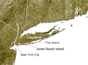
Jones Beach Island

Jones Beach Island
Jones Beach Island is one of the outer barrier islands off the southern coast of Long Island in the U.S. state of New York. It is named for Major Thomas Jones, who first came to Long Island in 1692, where he proceeded to build the island's first brick house near Massapequa. Jones built a whaling station on Jones Island near the present site of Jones Beach State Park in 1700.[1] Jones Beach Island is sometimes referred to as Oak Beach Island and is the former home of the infamous Oak Beach Inn.[2]
Geography
Jones Beach Island is separated from Long Island by Great South Bay, Jones Inlet and Fire Island Inlet. Because of the ephemeral nature of the various inlets, the name "Fire Island" is sometimes used to refer collectively to the various barrier islands off the south shore of Long Island, but also refers specifically to the island across the Fire Island Inlet to the east. Jones Beach Island straddles the county line between Nassau and Suffolk counties and includes the census-designated places of Gilgo and Oak Beach–Captree, New York.[3]
The southern side of the island is known for its beaches that face the open Atlantic Ocean. The best known of the public beaches on the island,[4]Jones Beach State Park on the western tip of the island, is a summer recreational destination for the New York City area.[5]
Jones Beach Island is accessible from Long Island on its western end by the Meadowbrook State Parkway to Merrick, the Loop Parkway to Long Beach, and the Wantagh State Parkway to Wantagh. Its eastern end is linked to Babylon as well as to Fire Island by the Robert Moses Causeway. The Ocean Parkway connects all three causeways and runs the length of the island.[6]
See also
- Captree State Park
- West Gilgo Beach
References
^ "Jones Beach State Park: History". JonesBeach.org. Retrieved 2012-11-20..mw-parser-output cite.citationfont-style:inherit.mw-parser-output qquotes:"""""""'""'".mw-parser-output code.cs1-codecolor:inherit;background:inherit;border:inherit;padding:inherit.mw-parser-output .cs1-lock-free abackground:url("//upload.wikimedia.org/wikipedia/commons/thumb/6/65/Lock-green.svg/9px-Lock-green.svg.png")no-repeat;background-position:right .1em center.mw-parser-output .cs1-lock-limited a,.mw-parser-output .cs1-lock-registration abackground:url("//upload.wikimedia.org/wikipedia/commons/thumb/d/d6/Lock-gray-alt-2.svg/9px-Lock-gray-alt-2.svg.png")no-repeat;background-position:right .1em center.mw-parser-output .cs1-lock-subscription abackground:url("//upload.wikimedia.org/wikipedia/commons/thumb/a/aa/Lock-red-alt-2.svg/9px-Lock-red-alt-2.svg.png")no-repeat;background-position:right .1em center.mw-parser-output .cs1-subscription,.mw-parser-output .cs1-registrationcolor:#555.mw-parser-output .cs1-subscription span,.mw-parser-output .cs1-registration spanborder-bottom:1px dotted;cursor:help.mw-parser-output .cs1-hidden-errordisplay:none;font-size:100%.mw-parser-output .cs1-visible-errorfont-size:100%.mw-parser-output .cs1-subscription,.mw-parser-output .cs1-registration,.mw-parser-output .cs1-formatfont-size:95%.mw-parser-output .cs1-kern-left,.mw-parser-output .cs1-kern-wl-leftpadding-left:0.2em.mw-parser-output .cs1-kern-right,.mw-parser-output .cs1-kern-wl-rightpadding-right:0.2em
^ "Hofstra University: Study of Beaches on Jones Beach Island". hofstra.edu. Hofstra University.
^ "P.L. 94-171 County Block Map (2010 Census): Suffolk County, NY" (PDF). U.S. Census Bureau. Retrieved 2012-12-28.
^ "Jones Beach State Park: History". JonesBeach.org. Retrieved 2012-11-20.
^ "Hofstra University: Study of Beaches on Jones Beach Island". hofstra.edu. Hofstra University.
^ "Hofstra University: Study of Beaches on Jones Beach Island". hofstra.edu. Hofstra University.
Coordinates: 40°35′46″N 73°30′28″W / 40.596234°N 73.507861°W / 40.596234; -73.507861 (Jones Beach Island)

 Clash Royale CLAN TAG#URR8PPP