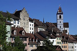
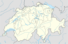
阿劳
| 阿勞 | ||||||||||
|---|---|---|---|---|---|---|---|---|---|---|
 Aarau old city | ||||||||||
| ||||||||||
| 人口 | 20,043 (2011年12月)[1] | |||||||||
| - 密度 | 1,624 /km2 | |||||||||
面積 | 12.33 km2[2] | |||||||||
| 海拔 | 381米(1,250英尺) | |||||||||
| - 最高 | 471 m - Hungerberg | |||||||||
| - 最低 | 365 m - Aar | |||||||||
| 郵政編碼 | 5000 | |||||||||
| SFOS數據 | 4001 | |||||||||
| 市長 | Marcel Guignard (as of 2004) FDP/PRD | |||||||||
周圍城市 | Rohr, Buchs, Suhr, Unterentfelden, Eppenberg-Wöschnau, Erlinsbach | |||||||||
| 姐妹鎮 | Neuchâtel (Switzerland), Delft (Netherlands), Reutlingen (Germany) | |||||||||
| 網站 | www.aarau.ch SFSO statistics | |||||||||
 阿勞 | ||||||||||
阿勞地圖  | ||||||||||


阿劳(德语:Aarau)是位于瑞士北部侏罗山南麓的一座城市,也是阿尔高州的首府,人口15,649(2005年)。居民多信奉新教,主要使用德语。
阿劳于1240年建城,1798年为海尔维第共和国首都。
参考资料
^ Canton of Aargau Statistical Office, MS Excel document – Bevölkerungsbestand 2011 nach Gemeinde, Geschlecht u. Nationalität (per 31. Dezember 2011) (德文) accessed 2 May 2012
^ Arealstatistik Standard - Gemeindedaten nach 4 Hauptbereichen
外部链接
维基共享资源中相关的多媒体资源:阿劳 |
- 阿劳官方网站
- 阿勞照片
|


