Regions of Pennsylvania
Regions of Pennsylvania
Jump to navigation
Jump to search
Geographic regions of the Commonwealth of Pennsylvania, United States of America.
Contents
1 Southeastern Pennsylvania
1.1 Delaware Valley
1.2 Pennsylvania Piedmont
1.3 Pennsylvania Dutch Country
2 Northeastern Pennsylvania
2.1 Northeastern Pennsylvania
2.2 The Poconos
2.3 Coal Region
2.4 Wyoming Valley
2.5 Endless Mountains
2.6 Northern Tier
3 Central Pennsylvania
3.1 Susquehanna River Valley
3.2 South Central Pennsylvania
3.3 Southern Alleghenies (West Central)
3.4 Happy Valley
3.5 Cumberland Valley
4 Western Pennsylvania
4.1 Laurel Highlands
4.2 Greater Pittsburgh
4.3 Allegheny National Forest
4.4 Pennsylvania's Northwest Region
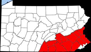
Southeastern Pennsylvania[edit]
Delaware Valley[edit]

Counties constituting the Delaware Valley Region of Pennsylvania
The Delaware Valley is named for the Delaware River which flows through the region.
Consisting of the following counties:
- Bucks
- Philadelphia
- Delaware
- Montgomery
- Chester
This valley primarily contains the Philadelphia metropolitan area.
Pennsylvania Piedmont[edit]
Counties constituting the Pennsylvania Piedmont Region
The Pennsylvania Piedmont region is a heavily agricultural section of the Piedmont Plateau located in Eastern Pennsylvania frequently cited as a candidate for extensive ecological preservation.
Consisting of the following counties:
- Franklin
- Adams
- Cumberland
- York
- Dauphin
- Lancaster
- Lebanon
- Chester
- Berks
- Montgomery
- Bucks
- Lehigh
- Northampton
Pennsylvania Dutch Country[edit]

Counties constituting the Pennsylvania Dutch Country Region
Pennsylvania Dutch Country refers to an area of southeastern Pennsylvania that has a high percentage of Amish, Mennonite and "Fancy Dutch" inhabitants and where the Pennsylvania German language was historically common.
Consisting of the following counties:
- Lehigh
- York
- Perry
- Cumberland
- Adams
- Lebanon
- Franklin
- Lancaster
Northeastern Pennsylvania[edit]
Northeastern Pennsylvania[edit]

Counties constituting Northeastern Pennsylvania
This mountainous area of Pennsylvania includes the Pocono Mountains, the Endless Mountains and former anthracite coal mining cities, boroughs, and villages.
Consisting of the following counties:
- Bradford County
- Carbon County
- Columbia County
- Lackawanna County
- Luzerne County
- Monroe County
- Montour County
- Northumberland County
- Pike County
- Schuylkill County
- Sullivan County
- Susquehanna County
- Wayne County
- Wyoming County
The Poconos[edit]

Counties constituting The Poconos
The Poconos, or the Pocono Mountains region, is a mountainous region of about 2,400 square miles (6,200 km²) located in northeastern Pennsylvania, approximately 30 miles north of Allentown, which are a popular recreational destination for local and regional visitors.
Consisting of the following counties:
- Carbon
- Monroe
- Pike
- Wayne
May be considered part of the Poconos
- Lackawanna
- Schuylkill
- Luzerne
- Susquehanna
Coal Region[edit]

Counties constituting the Anthracite Coal Region of Pennsylvania
The Coal Region is a term used to refer to an area of Northeastern Pennsylvania in the central Appalachian Mountains. The region is home to the largest known deposits of anthracite coal found in the Americas, with an estimated reserve of 7 billion tons.
- Schuylkill
- Carbon
- Northumberland
- Columbia
- Luzerne
- Lackawanna
Wyoming Valley[edit]
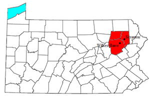
Counties constituting the Wyoming Valley Region of Pennsylvania
Wyoming Valley is a region of northeastern Pennsylvania. The valley is a crescent-shaped depression, a part of the ridge-and-valley or folded Appalachians, which includes the metropolitan areas of Scranton, and Wilkes-Barre, Pennsylvania.
Consisting of the following counties:
- Luzerne
- Lackawanna
- Wyoming
This valley primarily contains the Wilkes-Barre Metro Area and the Scranton Metro Area.
Endless Mountains[edit]

Counties constituting the Endless Mountains Region of Pennsylvania
The Endless Mountains are a chain of mountains in northeastern Pennsylvania which are part of the Appalachian Mountains chain. The "mountains" are not true mountains, geologically speaking, but are a dissected plateau and are part of the Allegheny Plateau, along with the higher Catskill Mountains to the east of the Endless Mountains in New York.
Consisting of the following counties:
- Sullivan
- Wyoming
- Bradford
- Susquehanna
Northern Tier[edit]

Counties constituting the Northern Tier Region of Pennsylvania
The Northern Tier is a geographic region in north-central Pennsylvania.
Consisting of the following counties:
- Sullivan
- Wyoming
- Bradford
- Susquehanna
- Tioga
- Potter
- McKean
Central Pennsylvania[edit]
Susquehanna River Valley[edit]

Counties constituting the Susquehanna River Valley Region of Pennsylvania. Those in red are those through which the river (and/or its largest tributary, the West Branch Susquehanna River) physically flows, dark red counties are part of the watershed.
The Susquehanna River is a river in the northeastern United States. At approximately 410 mi (715 km) long, it is the longest river on the American East Coast.
South Central Pennsylvania[edit]

Counties constituting the South Central region of Pennsylvania
South Central Pennsylvania is a geographic region that lies between the Delaware Valley and Western Pennsylvania, United States.
Consisting of the following counties:
- Adams
- Cumberland
- Dauphin
- Franklin
- Huntingdon
- Juniata
- Lancaster
- Lebanon
- Mifflin
- Perry
- Snyder
- York
Parts of these counties may be considered part of South Central Pennsylvania:
- Schuylkill
- Berks
- Northumberland
- Fulton
Southern Alleghenies (West Central)[edit]

Counties constituting the Southern Alleghenies region of Pennsylvania
Southern Alleghenies is a geographic region of West Central Pennsylvania, consisting of the following counties:
- Bedford
- Blair
- Cambria
- Fulton
- Huntingdon
- Somerset
Organizations serving the Southern Alleghenies region include:
- Southern Alleghenies Planning & Development Commission
- Southern Alleghenies Conservancy
- Southern Alleghenies Museum of Art
- Goodwill of the Southern Alleghenies
Happy Valley[edit]

Counties constituting the Happy Valley Region of Pennsylvania
Happy Valley is a large valley located in central Pennsylvania. The Pennsylvania State University is located in the valley.
Consisting of the following county:
- Centre
Cumberland Valley[edit]

Counties constituting the Cumberland Valley Region of Pennsylvania
The Cumberland Valley is a geographic region that lies between South Mountain and the Blue Ridge Mountains of central Pennsylvania and western Maryland, United States.
Consisting of the following counties:
- Cumberland
- Franklin
Western Pennsylvania[edit]
Laurel Highlands[edit]

Counties constituting the Laurel Highlands Region of Pennsylvania
The Laurel Highlands, in the southwestern part of the state of Pennsylvania, traverses the Laurel and Chestnut ridges of the Allegheny Mountains.
Consisting of the following counties:
- Fayette
- Somerset
- Cambria
- Westmoreland
Greater Pittsburgh[edit]

Counties constituting the Pittsburgh metropolitan area
Also known as Southwestern Pennsylvania, the region consists of the following counties:
- Allegheny
- Armstrong
- Beaver
- Butler
- Washington
- Westmoreland
- Fayette
Allegheny National Forest[edit]

Counties constituting the Allegheny National Forest Region of Pennsylvania
The Allegheny National Forest is a National Forest located in northwestern Pennsylvania. The forest covers over 500,000 acres (2,000 km²) of land.
Consisting of the following counties:
- Forest
- Elk
- Warren
- McKean
Pennsylvania's Northwest Region[edit]

Counties constituting Pennsylvania's Northwest Region
- Erie
- Crawford
- Mercer
- Venango
- Warren
- Lawrence
- Butler
- Clarion
- Forest
Harrisburg (capital) | |
| Topics |
|
| Society |
|
| Metro areas |
|
| Largest cities |
|
| Largest municipalities |
|
| Regions |
|
| Counties |
|
Categories:
- Regions of Pennsylvania
(window.RLQ=window.RLQ||).push(function()mw.config.set("wgPageParseReport":"limitreport":"cputime":"0.212","walltime":"0.281","ppvisitednodes":"value":717,"limit":1000000,"ppgeneratednodes":"value":0,"limit":1500000,"postexpandincludesize":"value":56616,"limit":2097152,"templateargumentsize":"value":9875,"limit":2097152,"expansiondepth":"value":13,"limit":40,"expensivefunctioncount":"value":0,"limit":500,"unstrip-depth":"value":0,"limit":20,"unstrip-size":"value":0,"limit":5000000,"entityaccesscount":"value":0,"limit":400,"timingprofile":["100.00% 105.606 1 -total"," 46.13% 48.714 18 Template:Main"," 41.51% 43.834 1 Template:Pennsylvania"," 37.81% 39.932 1 Template:US_state_navigation_box"," 32.86% 34.701 1 Template:Navbox"," 15.28% 16.138 1 Template:Flagdeco"," 6.97% 7.358 1 Template:See_also"," 6.42% 6.783 1 Template:Yesno-no"," 5.36% 5.663 1 Template:Country_data_Pennsylvania"," 3.84% 4.052 1 Template:Yesno"],"scribunto":"limitreport-timeusage":"value":"0.034","limit":"10.000","limitreport-memusage":"value":1604830,"limit":52428800,"cachereport":"origin":"mw1240","timestamp":"20190307235848","ttl":2592000,"transientcontent":false);mw.config.set("wgBackendResponseTime":97,"wgHostname":"mw1241"););


