Fresno Dome
Fresno Dome
Jump to navigation
Jump to search
| Fresno Dome | |
|---|---|
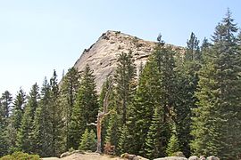
 Fresno Dome's northern face as seen from the Fresno Dome trail. | |
| Highest point | |
| Elevation | 7,544 ft (2,299 m) NAVD 88[1] |
| Prominence | 260 ft (79 m) [1] |
| Coordinates | 37°27′16″N 119°32′12″W / 37.4543843°N 119.5365338°W / 37.4543843; -119.5365338Coordinates: 37°27′16″N 119°32′12″W / 37.4543843°N 119.5365338°W / 37.4543843; -119.5365338 [2] |
| Geography | |
 Fresno Dome Show map of California  Fresno Dome Show map of the US | |
| Location | Sierra National Forest, Madera County, California, U.S. |
| Parent range | Sierra Nevada |
| Topo map | USGS White Chief Mountains |
| Geology | |
| Age of rock | Cretaceous |
| Mountain type | Granite dome |
| Climbing | |
| Easiest route | Trail hike (class 1)[3] |
Fresno Dome is a dominant granite dome rising in isolation above the forest of Soquel Meadow in the Sierra National Forest in Madera County, California.
The dome as known to the Mono Indians as "the greeting place" ("wah-me-yelo"). John Muir encountered Fresno Dome, calling it "Wamello", in the 1870s, and used its summit to locate Fresno Grove (now known as Nelder Grove).[4][5]
It is accessible by a trailhead which is a three-mile drive from the Sierra Vista Scenic Byway (part of the National Scenic Byway system).[3] The nearest town is Bass Lake, California, 9.1 miles (14.6 km) to the south.
At its base, sits the Fresno Dome campground, a backwoods campground accessible only by jeep trails. The campground is a favorite spot for deer hunters and is largely empty other than during deer season. The dome offers several technical free climbs rated class 5 or better,[6] with "Guides in a Snowbank" rated at 5.10a.[5]
See also[edit]
- Half Dome
- Lembert Dome
- Batholith
- Geology of the Yosemite area
References[edit]
^ ab "Fresno Dome, California". Peakbagger.com..mw-parser-output cite.citationfont-style:inherit.mw-parser-output qquotes:"""""""'""'".mw-parser-output code.cs1-codecolor:inherit;background:inherit;border:inherit;padding:inherit.mw-parser-output .cs1-lock-free abackground:url("//upload.wikimedia.org/wikipedia/commons/thumb/6/65/Lock-green.svg/9px-Lock-green.svg.png")no-repeat;background-position:right .1em center.mw-parser-output .cs1-lock-limited a,.mw-parser-output .cs1-lock-registration abackground:url("//upload.wikimedia.org/wikipedia/commons/thumb/d/d6/Lock-gray-alt-2.svg/9px-Lock-gray-alt-2.svg.png")no-repeat;background-position:right .1em center.mw-parser-output .cs1-lock-subscription abackground:url("//upload.wikimedia.org/wikipedia/commons/thumb/a/aa/Lock-red-alt-2.svg/9px-Lock-red-alt-2.svg.png")no-repeat;background-position:right .1em center.mw-parser-output .cs1-subscription,.mw-parser-output .cs1-registrationcolor:#555.mw-parser-output .cs1-subscription span,.mw-parser-output .cs1-registration spanborder-bottom:1px dotted;cursor:help.mw-parser-output .cs1-hidden-errordisplay:none;font-size:100%.mw-parser-output .cs1-visible-errorfont-size:100%.mw-parser-output .cs1-subscription,.mw-parser-output .cs1-registration,.mw-parser-output .cs1-formatfont-size:95%.mw-parser-output .cs1-kern-left,.mw-parser-output .cs1-kern-wl-leftpadding-left:0.2em.mw-parser-output .cs1-kern-right,.mw-parser-output .cs1-kern-wl-rightpadding-right:0.2em
^ "Fresno Dome". Geographic Names Information System. United States Geological Survey.
^ ab Warszawski, Marek. "Hiking the Fresno Dome". The Fresno Bee. Archived from the original on 2015-08-22. Retrieved 2016-04-12.
^ Browning, Peter (1986). Place Names of the Sierra Nevada. Berkeley: Wilderness Press. p. 75. ISBN 0899971199.
^ ab "Fresno Dome (Wamello)". Mountain project, Inc. Retrieved 2014-01-16.
^ Roper, Steve (1976). The Climber's Guide to the High Sierra. San Francisco: Sierra Club Books. p. 149. ISBN 9780871561473.
This Madera County, California-related article is a stub. You can help Wikipedia by expanding it. |
Categories:
- Granite domes
- Mountains of Madera County, California
- Sierra National Forest
- Mountains of the Sierra Nevada (U.S.)
- Mountains of Northern California
- Madera County, California geography stubs
(window.RLQ=window.RLQ||).push(function()mw.config.set("wgPageParseReport":"limitreport":"cputime":"0.304","walltime":"0.399","ppvisitednodes":"value":1856,"limit":1000000,"ppgeneratednodes":"value":0,"limit":1500000,"postexpandincludesize":"value":54743,"limit":2097152,"templateargumentsize":"value":8078,"limit":2097152,"expansiondepth":"value":11,"limit":40,"expensivefunctioncount":"value":2,"limit":500,"unstrip-depth":"value":1,"limit":20,"unstrip-size":"value":15660,"limit":5000000,"entityaccesscount":"value":1,"limit":400,"timingprofile":["100.00% 359.140 1 -total"," 64.37% 231.190 1 Template:Infobox_mountain"," 55.02% 197.586 1 Template:Infobox"," 30.86% 110.839 1 Template:Reflist"," 21.85% 78.482 4 Template:Cite_web"," 19.24% 69.095 1 Template:Cite_peakbagger"," 11.31% 40.629 4 Template:Convert"," 8.27% 29.709 1 Template:Coord"," 6.28% 22.548 1 Template:Location_map"," 6.22% 22.354 10 Template:Ifempty"],"scribunto":"limitreport-timeusage":"value":"0.167","limit":"10.000","limitreport-memusage":"value":5219527,"limit":52428800,"cachereport":"origin":"mw1248","timestamp":"20181201023021","ttl":1900800,"transientcontent":false););"@context":"https://schema.org","@type":"Article","name":"Fresno Dome","url":"https://en.wikipedia.org/wiki/Fresno_Dome","sameAs":"http://www.wikidata.org/entity/Q5503178","mainEntity":"http://www.wikidata.org/entity/Q5503178","author":"@type":"Organization","name":"Contributors to Wikimedia projects","publisher":"@type":"Organization","name":"Wikimedia Foundation, Inc.","logo":"@type":"ImageObject","url":"https://www.wikimedia.org/static/images/wmf-hor-googpub.png","datePublished":"2004-08-17T04:58:31Z","dateModified":"2018-01-18T16:48:07Z","image":"https://upload.wikimedia.org/wikipedia/commons/4/42/Fresno_Dome_2004.jpg","headline":"mountain in United States of America"(window.RLQ=window.RLQ||).push(function()mw.config.set("wgBackendResponseTime":115,"wgHostname":"mw1273"););

